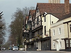
Chigwell
| Chigwell | |
|---|---|
 The former Olde King's Head |
|
| Chigwell shown within Essex | |
| Area | 15.68 km2 (6.05 sq mi) |
| Population | 12,449 (2001) 12,987 (2011) |
| • Density | 794/km2 (2,060/sq mi) |
| OS grid reference | TQ435935 |
| • London | 12 mi (19 km) SW |
| Civil parish |
|
| District | |
| Shire county | |
| Region | |
| Country | England |
| Sovereign state | United Kingdom |
| Post town | CHIGWELL |
| Postcode district | IG7 |
| Dialling code | 020 |
| Police | Essex |
| Fire | Essex |
| Ambulance | East of England |
| EU Parliament | East of England |
| UK Parliament | |
| Website | Chigwell Parish Council |
Chigwell is a civil parish and town in the Epping Forest district of Essex. It is an outlying suburb of London, located 12 miles (19 kilometres) north-east of Charing Cross. Along with the neighbouring suburban areas of Loughton and Buckhurst Hill, Chigwell forms part of the so-called "golden triangle" of Essex.
According to P. H. Reaney's Place-Names of Essex, the standard guide to etymology in the county, the name means 'Cicca's well', Cicca being an Anglo-Saxon personal name. In medieval sources the name appears with a wide variety of spellings including "Cinghe uuella" and Chikewelle". Folk etymology has sought to derive the name from a lost "king's well", supposed to have been to the south-east of the parish near the border of what is now the London Borough of Redbridge. There were several medicinal springs in Chigwell Row documented by Miller Christy in his book History of the mineral waters and medicinal springs of the county of Essex, published in 1910. The proposal by 18th-century local historian Nathaniel Salmon that the "-well" element in the name derives from Anglo-Saxon weald (forest), indicating Chigwell's location in a royal demesne rather than Anglo-Saxon wielle (well) has long been superseded by modern onomastic study and is no longer credible.
The land registration map of Redbridge Council shows "Chig Well (site of)" as being located to the rear of the house located at 67 Brocket Way, Chigwell.
Traditionally a rural farming community, but now largely suburban, Chigwell was mentioned in the Domesday Book. It was later spoke about by Charles Dickens in his novel Barnaby Rudge: A Tale of the Riots of 'Eighty; the Maypole Inn is based on the King's Head inn, though the name was taken from the Maypole public house in Chigwell Row; and it is likely Dickens visited both hostelries. Dickens frequently visited Chigwell, which he described in a letter as "the greatest place in the world...Such a delicious old inn opposite the church...such beautiful forest scenery...such an out of the way rural place!".
...
Wikipedia

