Chicopee Falls, Massachusetts
| Chicopee, Massachusetts | ||
|---|---|---|
| City | ||

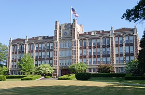
The former Chicopee High School
|
||
|
||
| Nickname(s): Crossroads of New England | ||
| Motto: Industriae Variae (Varied Industries) | ||
 Location in Hampden County in Massachusetts |
||
| Location in the United States | ||
| Coordinates: 42°08′55″N 72°36′30″W / 42.14861°N 72.60833°WCoordinates: 42°08′55″N 72°36′30″W / 42.14861°N 72.60833°W | ||
| Country | United States | |
| State | Massachusetts | |
| County | Hampden | |
| Settled | 1640 | |
| Incorporated (town) | 1848 | |
| Incorporated (city) | 1890 | |
| Government | ||
| • Type | Mayor-council city | |
| • Mayor | Richard Kos (R) | |
| Area | ||
| • Total | 23.9 sq mi (61.9 km2) | |
| • Land | 22.9 sq mi (59.2 km2) | |
| • Water | 1.0 sq mi (2.7 km2) | |
| Elevation | 200 ft (61 m) | |
| Population (2009) | ||
| • Total | 55,298 | |
| • Density | 2,313.7/sq mi (893.3/km2) | |
| Time zone | Eastern (UTC-5) | |
| • Summer (DST) | Eastern (UTC-4) | |
| ZIP code | 01013, 01020, 01021 | |
| Area code(s) | 413 | |
| FIPS code | 25-13660 | |
| GNIS feature ID | 0617597 | |
| Website | www.chicopeema.gov | |
Chicopee (/ˈtʃɪkəpi/ CHIK-ə-pee) is a city located on the Connecticut River in Hampden County, Massachusetts, United States of America. It is part of the Springfield, Massachusetts Metropolitan Statistical Area. As of the 2010 census, the city had a population of 55,298, making it the second largest city in Western Massachusetts after Springfield. The current mayor is Richard Kos.
Chicopee uses the nickname “Crossroads of New England” as part of a business-development marketing campaign. The name reflects the city's convenient location amongst a number of metropolitan areas and its transportation network. Four highways run through its boundaries: I-90, I-91, I-291, and I-391. State routes such as Route 33, 116, and 141, are major providers of regional linkage.
The communities of Chicopee Center (Cabotville), Chicopee Falls, Willimansett, Fairview, Smith Highlands, Aldenville, Burnett Road, and Westover are located in the city.
The city is named after the Chicopee River, whose mouth empties into the Connecticut River on in its boundaries. "Chicopee" is a Nipmuc word, probably from chekee ("violent") and pe ("waters") in most Algonquian dialects, with reference to rapids. The Nipmucs were the indigenous people of the lands that today make up the City of Chicopee, prior to the arrival of European colonists.
...
Wikipedia


