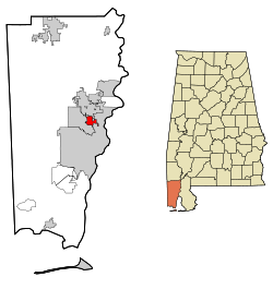
Chickasaw, Alabama
| Chickasaw | |
|---|---|
| City | |
 |
|
| Coordinates: 30°45′53″N 88°5′1″W / 30.76472°N 88.08361°WCoordinates: 30°45′53″N 88°5′1″W / 30.76472°N 88.08361°W | |
| Country | United States |
| State | Alabama |
| County | Mobile |
| Area | |
| • Total | 4.5 sq mi (11.9 km2) |
| • Land | 4.4 sq mi (11.5 km2) |
| • Water | 0.1 sq mi (0.4 km2) |
| Elevation | 30 ft (9 m) |
| Population (2010) | |
| • Total | 6,106 |
| Time zone | Central (CST) (UTC-6) |
| • Summer (DST) | CDT (UTC-5) |
| ZIP code | 36611, 36671 |
| Area code(s) | 251 |
| FIPS code | 01-14392 |
| GNIS feature ID | 0116030 |
| Website | www |
Chickasaw is a city in Mobile County, Alabama, United States. As of the 2010 U.S. Census the population is 6,106, a decline from 6,364 in 2000. It is included in the Mobile metropolitan statistical area.
Chickasaw is located at 30°45′54″N 88°05′01″W / 30.764987°N 88.083713°W. According to the U.S. Census Bureau, the city has a total area of 4.6 square miles (12 km2), of which 4.4 square miles (11 km2) is land and 0.1 square miles (0.26 km2) (3.06%) is water.
As of the census of 2000, there were 6,364 people, 2,747 households, and 1,747 families residing in the city. The population density was 1,436.3 people per square mile (554.7/km2). There were 2,989 housing units at an average density of 674.6 per square mile (260.5/km2). The racial makeup of the city was 88.89% White, 8.12% Black or African American, 1.35% Native American, 0.24% Asian, 0.02% Pacific Islander, 0.30% from other races, and 1.08% from two or more races. 1.15% of the population were Hispanic or Latino of any race.
...
Wikipedia
