Chess Valley
| Chess | |
| River | |
|
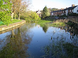
River Chess at Waterside, Chesham
|
|
| Country | England |
|---|---|
| Counties | Buckinghamshire, Hertfordshire |
| Towns/Cities | Chesham, Rickmansworth |
| Source | |
| - location | Chesham Vale, Pednor |
| Mouth | |
| - location | River Colne at Rickmansworth |
| Length | 17.9 km (11 mi) |
Coordinates: GB_scale:50000 51°42′22″N 0°36′36″W / 51.706°N 0.610°W
The River Chess, a chalk stream, rises just north of Chesham in the Chiltern Hills, to flow through Buckinghamshire and Hertfordshire to join the River Colne in Rickmansworth. The Chess, along with the Colne and Gade, gives rise to the name of the district of Three Rivers, where it forms its confluence with the Colne at Rickmansworth.
The River Chess fall is 60 metres and its length is 11 miles (18 km).
Its name arose by back-formation from the name of Chesham. It was once known as the Pittlesburne which incorporates the old word burna used in the Chilterns to describe a clear spring-fed stream on a lower dip-slope, often with a stony bed. Examples are the rivers Misbourne and Bulbourn, and the river Ver was formerly the Redbourne.
The Chess is fed by groundwater held in the chalk aquifer of the Chiltern Hills and rises from three springs which surface as Vale brook, from Bury Pond, and alongside the Missenden Road near Pednor just to the north of Chesham. It flows within culverts beneath the town before flowing in a southeasterly direction through Waterside. The river flows below parkland landscaped by Capability Brown at Latimer House and the site of a 1st Century Roman villa close to the village of Latimer; to the north of Chenies; through unimproved water meadows at Frogmore and the watercress beds at Sarratt Bottom to the west of Sarratt. The Chess flows under the M25 motorway at Solesbridge Lane, before passing through the private housing estate of Loudwater, whose name was historically associated with the river at this point. Below this the river passes several disused water mills which supplied power and water for paper manufacture during the 18th and 19th Centuries. At Rickmansworth it joins the River Colne to the east of the town. The river banks are mostly not public rights of way, and only small stretches of the river are accessible. It is navigable only in its lower reaches.
...
Wikipedia

