Cheboygan River
| Cheboygan River | |
|---|---|

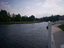
Cheboygan River flowing through Cheboygan
|
|
| Country | United States |
| Basin features | |
| Main source |
Mullett Lake 594 ft (181 m) |
| River mouth |
Lake Huron at Cheboygan 581 ft (177 m) |
| Physical characteristics | |
| Length | 7.0 mi (11.3 km) |
The Cheboygan River is a short but significant river in the Lake Huron drainage basin of the U.S. state of Michigan.
Seven miles (11.3 km) in length, the Cheboygan River flows from the north end of Mullett Lake at 45°34′37″N 84°29′16″W / 45.57694°N 84.48778°W to the Straits of Mackinac at 45°39′22″N 84°27′55″W / 45.65611°N 84.46528°W. The river forms the boundary between Benton Township and Inverness Township before flowing into the city of Cheboygan. The largest tributary is the Black River. The Cheboygan River is entirely contained within Michigan's Cheboygan County, and the county seat of Cheboygan is located at the river's mouth. The river forms the port of Cheboygan and serves as a dock for the ferry boat to Bois Blanc Island and the Coast Guard cutter Mackinaw.
...
Wikipedia
