Cheap (ward)
| Ward of Cheap | |
|---|---|
 Location within the City |
|
| Ward of Cheap shown within Greater London | |
| OS grid reference | TQ321812 |
| Sui generis | |
| Administrative area | Greater London |
| Region | |
| Country | England |
| Sovereign state | United Kingdom |
| Post town | LONDON |
| Postcode district | EC1, EC4 |
| Dialling code | 020 |
| Police | City of London |
| Fire | London |
| Ambulance | London |
| EU Parliament | London |
| UK Parliament | |
| London Assembly | |
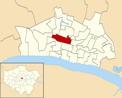
Cheap is a small ward in the City of London. It stretches west to east from King Edward Street, the border with Farringdon Within ward, to Old Jewry, which adjoins Walbrook; and north to south from Gresham Street, the border with Aldersgate and Bassishaw wards, to Cheapside, the boundary with Cordwainer and Bread Street wards. The name Cheap derives from the Old English word "chep" for "market".
The following roads run north to south across the ward: St. Martin's Le Grand,Foster Lane, Gutter Lane, Wood Street, Milk Street, King Street, and Ironmonger Lane. Within its boundaries are two Anglican churches: St Vedast Foster Lane and St Lawrence Jewry; a third church, St Mildred, Poultry, was demolished in 1872. Several Livery Halls are located in Cheap, including those of the Mercers', Goldsmiths', Wax Chanders' and Saddlers' Companies.
...
Wikipedia

