Chatham Street (Manhattan)

|
|
| Coordinates | 40°25′27″N 74°01′20″W / 40.4243°N 74.0221°W |
|---|---|
| West end | Broadway/Vesey Street/Ann Street |
| East end | Chatham Square |
Route map: Google
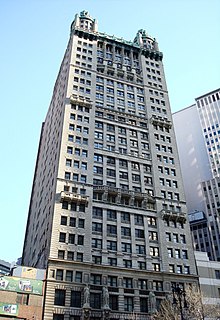
Park Row is a street located in the Financial District, Civic Center, and Chinatown neighborhoods of the New York City borough of Manhattan. The street runs east-west, sometimes called north-south because the western end is nearer to Downtown Manhattan. At the north end of Park Row is the confluence of Bowery, East Broadway, St. James Place, Oliver Street, Mott Street, and Worth Street at Chatham Square. At the street's south end, Broadway, Vesey Street, Barclay Street, and Ann Street intersect. The intersection includes a bus turnaround loop designated as Millennium Park. Park Row was once known as Chatham Street; it was renamed Park Row in 1886, a reference to the fact that it faces City Hall Park, the former New York Common.
In the late 18th century Eastern Post Road became the more important road connecting New York to Albany and New England. This section of the road which became Park Row was called Chatham Street, a name that enters into the city's history on numerous occasions.
...
Wikipedia
