Charmey (Gruyère)
| Charmey | ||
|---|---|---|
| Former municipality of Switzerland | ||

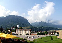
Charmey village
|
||
|
||
| Coordinates: 46°37′N 7°10′E / 46.617°N 7.167°ECoordinates: 46°37′N 7°10′E / 46.617°N 7.167°E | ||
| Country | Switzerland | |
| Canton | Fribourg | |
| District | Gruyère | |
| Area | ||
| • Total | 78.44 km2 (30.29 sq mi) | |
| Elevation | 887 m (2,910 ft) | |
| Highest elevation | 2,389 m (7,838 ft) | |
| Lowest elevation | 800 m (2,600 ft) | |
| Population (Dec 2011) | ||
| • Total | 1,852 | |
| • Density | 24/km2 (61/sq mi) | |
| Postal code | 1637 | |
| SFOS number | 2127 | |
| Surrounded by | Bas-Intyamon, Broc, Cerniat, Château-d'Œx (VD), Crésuz, Grandvillard, Gruyères, Jaun, Plaffeien, Rougemont (VD), Saanen (BE) | |
| Twin towns | Orphin (France) | |
| Website |
www SFSO statistics |
|
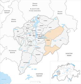
Charmey is a former municipality in the district of Gruyère in the canton of Fribourg in Switzerland. On 1 January 2014 the former municipalities of Charmey and Cerniat merged into the new municipality of Val-de-Charmey.
Charmey is first mentioned in 1211 as Chalmeis. Until 1760 it was known as Feiguières. The municipality is also informally known by its German name Galmis.
Before the merger, Charmey had a total area of 78.5 km2 (30.3 sq mi). Of this area, 35.25 km2 (13.61 sq mi) or 44.9% is used for agricultural purposes, while 28.56 km2 (11.03 sq mi) or 36.4% is forested. Of the rest of the land, 1.62 km2 (0.63 sq mi) or 2.1% is settled (buildings or roads), 0.66 km2 (0.25 sq mi) or 0.8% is either rivers or lakes and 12.38 km2 (4.78 sq mi) or 15.8% is unproductive land.
Of the built up area, housing and buildings made up 1.0% and transportation infrastructure made up 0.7%. Out of the forested land, 31.5% of the total land area is heavily forested and 3.8% is covered with orchards or small clusters of trees. Of the agricultural land, 5.2% is pastures and 39.7% is used for alpine pastures. Of the water in the municipality, 0.5% is in lakes and 0.4% is in rivers and streams. Of the unproductive areas, 9.7% is unproductive vegetation and 6.1% is too rocky for vegetation.
The former municipality is located in the Gruyère district, in the Jaun stream valley. It is the largest municipality in the canton. It consists of the village of Charmey, six hamlets and a number of small alpine settlements and camps.
The lake Schwarzsee/Lac Noir is located partially in the municipality.
The blazon of the municipal coat of arms is Gules, a bend Argent, overall a Pine Tree Vert issuant from Triple Caves Sable.
Charmey had a population (as of 2011) of 1,852. As of 2008[update], 12.9% of the population are resident foreign nationals. Over the last 10 years (2000–2010) the population has changed at a rate of 16.7%. Migration accounted for 17.5%, while births and deaths accounted for -0.1%. Most of the population (as of 2000[update]) speaks French (1,385 or 88.0%) as their first language, German is the second most common (115 or 7.3%) and Portuguese is the third (27 or 1.7%). There are 2 people who speak Italian.
...
Wikipedia


