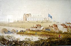
Charlemont Fort
| Charlemont Fort | |
|---|---|
| Charlemont, County Armagh | |

Charlemont Fort in the 18th century
|
|
|
Location within Northern Ireland
|
|
| Coordinates | 54°26′53″N 06°40′44″W / 54.44806°N 6.67889°WCoordinates: 54°26′53″N 06°40′44″W / 54.44806°N 6.67889°W |
| Type | Barracks |
| Site history | |
| Built | 1602 |
| In use | 1602-1858 |
Charlemont Fort was a garrison situated in Charlemont, County Armagh.
The fort was built in 1602 by Lord Mountjoy. The name Charlemont came from Charles Blount's Christian name. It was situated on the Armagh bank of the River Blackwater, it was armed with 150 men under the command of Sir Toby Caulfield, whose descendants took the name Charlemont from the place.
The Stronghold of Charlemont proved to be of great strategic importance in the Irish Confederate Wars in the 1640s, as it was one of only a handful of modern fortresses to be found in Ireland at that time. It was captured by the forces of Felim O'Neill in 1641 and the Ulster army of the Irish Confederates managed to hold on to the fort throughout the 1640s. It was eventually captured by Charles Coote after he had been reinforced by New Model Army soldiers in late 1650, but hundreds of Coote's soldiers were killed in the effort. The fort ceased to be used as a garrison on 14 February 1858. It was destroyed in 1920 by fire and the only building remaining today is the gatehouse.
Governors of Charlemont included:
The office was abolished on the death of the last holder in 1834.
On 30 July 1920 a group of around forty armed men seized the fort, which was being occupied by a caretaker, and burned it down. The ruins were sold in 1921 to a masonry contractor. In 1920 the family also lost their great house Roxborough Castle, Dungannon County Tyrone to the same fate.
...
Wikipedia

