Chandler's Ford
| Chandler's Ford | |
|---|---|
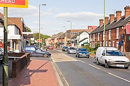
 Junction of Winchester Road and Brownhill Road, Chandler's Ford |
|
| Chandler's Ford shown within Hampshire | |
| Population | 21,436 |
| OS grid reference | SU435212 |
| Civil parish |
|
| District | |
| Shire county | |
| Region | |
| Country | England |
| Sovereign state | United Kingdom |
| Post town | EASTLEIGH |
| Postcode district | SO53 |
| Dialling code | 023 |
| Police | Hampshire |
| Fire | Hampshire |
| Ambulance | South Central |
| EU Parliament | South East England |
| UK Parliament | |
Chandler's Ford (originally The Ford and historically Chandlersford) is a largely residential area and civil parish in the Borough of Eastleigh in Hampshire, England, with a population of 21,436 in the 2011 UK Census.
Chandler's Ford lies on the old Winchester to Southampton road and the 'Ford' is thought to refer either to the ford of Monks Brook on the Hursley Road (shown on the Hursley map of 1588 as "Charnells foord") or on the Winchester-Southampton road. The "Chandler's" prefix was added in the late 16th century, and is derived from the surname, Chaundler, of a family in the area from the 14th Century.
The head offices of Draper Tools,B&Q, Selwood and Ahmad Tea are located in Chandler's Ford. Draper Tools has recently announced that they plan to move to Test Valley where they are currently building a new complex.
Hiltonbury Farm (now a public house) appeared on a map of 1588 and may originally have been owned by the Hursley Park Estate in nearby Hursley. It was later sold to Cranbury Park Estate and stopped being a working farm in the late 1970s, when the surrounding area was developed. Other communities revolved around other farms in the area but Chandler's Ford was very sparsely populated until the 19th century.
In 1889, an iron church and some schools were constructed. The civil parish of Chandlersford was created in 1897, from portions of North Stoneham, North Baddesley, and Ampfield, although the railway station remained in the North Baddesley parish.
Chandler's Ford used to be a town with mainly housing estates, however there are now various developments of shops and schools that have been built in the area. In the 1920s, building took place in the King's Court, Merdon and Hiltingbury areas. Later, development in the Hursley Road area happened, followed by housing across the Hiltingbury, Scantabout, Peverells Road, Spring Hill and Oakmount areas. More recently, developments in North Millers Dale, South Millers Dale and the 'new town' of Valley Park to the West of Chandler's Ford have completed the mix of housing. Chandler's Ford is considered to be the development to the West of the M3 motorway and now forms the majority of the Eastleigh urban area.
...
Wikipedia

