Chajul
|
Chajul San Gaspar Chajul |
|
|---|---|
| Municipality | |

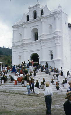
Church in Chajul in the 1950s
|
|
| Location in Guatemala | |
| Coordinates: 15°29′14″N 91°02′05″W / 15.48722°N 91.03472°WCoordinates: 15°29′14″N 91°02′05″W / 15.48722°N 91.03472°W | |
| Country |
|
| Department |
|
| Municipality | Chajul |
| Government | |
| • Type | Municipal |
| Population (Census 2002) | |
| • Municipality | 31,780 |
| • Urban | 10,095 |
| • Ethnicities | Ixil, K'iche' people, Ladino |
| • Religions | Roman Catholicism, Evangelicalism, Maya |
| Climate | Cfb |
Chajul (Spanish pronunciation: [tʃaˈxul]; full name San Gaspar Chajul) is a municipality in the Guatemalan department of El Quiché. Chajul is part of the Ixil Community, along with San Juan Cotzal and Santa Maria Nebaj. The Ixil region is isolated by beautiful mountains and has maintained its rich Ixil Mayan traditions and language. Chajul, Nebaj, and Cotzal make up the Ixil Region in the Department of Quiché in the Western Highlands of Guatemala. Having been at the heart of the 36-year civil war, Chajul experiences post-war challenges such as emotional trauma, land displacement, and fragmented families. Additionally, unemployment is high, large families live in one-room adobe houses with open cooking fires, opportunities for women are scarce, and family- and gender-based violence are common. The community has a corn-based agricultural economy in which adults struggle daily to feed their families and the average income is $1–3 per day. A 2002 study revealed that less than 1% of children graduate from high school (5% from middle school) as they are forced to leave school at a young age to help support the family household, leaving 75% of the adult population illiterate. Chajul further suffers from common preventable health concerns, such as respiratory illness, intestinal disease, tuberculosis, malnutrition, and death during childbirth. Eighty percent of the Chajul population lives in poverty.
The Northern Transversal Strip was officially created during the government of General Carlos Arana Osorio in 1970, by Legislative Decree 60-70, for agricultural development. The decree literally said: "It is of public interest and national emergency, the establishment of Agrarian Development Zones in the area included within the municipalities: San Ana Huista, San Antonio Huista, Nentón, Jacaltenango, San Mateo Ixtatán, and Santa Cruz Barillas in Huehuetenango; Chajul and San Miguel Uspantán in Quiché; Cobán, Chisec, San Pedro Carchá, Lanquín, Senahú, Cahabón and Chahal, in Alta Verapaz and the entire department of Izabal."
...
Wikipedia

