Chénens
| Chénens | ||
|---|---|---|
 |
||
|
||
| Coordinates: 46°44′N 7°0′E / 46.733°N 7.000°ECoordinates: 46°44′N 7°0′E / 46.733°N 7.000°E | ||
| Country | Switzerland | |
| Canton | Fribourg | |
| District | Sarine | |
| Government | ||
| • Mayor | Syndic | |
| Area | ||
| • Total | 3.95 km2 (1.53 sq mi) | |
| Elevation | 696 m (2,283 ft) | |
| Population (Dec 2015) | ||
| • Total | 854 | |
| • Density | 220/km2 (560/sq mi) | |
| Postal code | 1744 | |
| SFOS number | 2177 | |
| Surrounded by | Autigny, La Brillaz, La Folliaz, Villorsonnens | |
| Website |
www SFSO statistics |
|
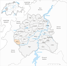
Chénens (Arpitan: ![]() Tsinin ) is a municipality in the district of Sarine in the canton of Fribourg in Switzerland. A French-speaking community, its earlier German name of Geiningen is no longer in common use.
Tsinin ) is a municipality in the district of Sarine in the canton of Fribourg in Switzerland. A French-speaking community, its earlier German name of Geiningen is no longer in common use.
Chénens is first mentioned in 1138 as Cheineis.
As of 2009[update] Chénens has an area of 4 square kilometers (1.5 sq mi). 2.68 km2 (1.03 sq mi) or 67.8% is used for agricultural purposes, while 0.89 km2 (0.34 sq mi) or 22.5% is forested. The rest of the region 0.4 km2 (0.15 sq mi) or 10.1% is settled (buildings or roads).
Housing and buildings made up 4.8% and transportation infrastructure made up 3.0%. Power and water infrastructure as well as other special developed areas make up 1.3% of the area. All of the forested land area is covered with dense forests. Of the agricultural land, 42.3% is used for growing crops and 24.3% is pasturage, while 1.3% is used for orchards or vine crops.
The municipality is located in the Sarine district on the cantonal highway between Fribourg and Romont (FR).
The blazon of the municipal coat of arms is Gules a Mastiff Argent passant gorged Or.
...
Wikipedia


