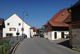
Châbles
| Châbles | ||
|---|---|---|
| Former municipality of Switzerland | ||
 |
||
|
||
| Coordinates: 46°50′N 6°48′E / 46.833°N 6.800°ECoordinates: 46°50′N 6°48′E / 46.833°N 6.800°E | ||
| Country | Switzerland | |
| Canton | Fribourg | |
| District | Broye | |
| Government | ||
| • Mayor | Syndic | |
| Area | ||
| • Total | 4.70 km2 (1.81 sq mi) | |
| Elevation | 571 m (1,873 ft) | |
| Population (December 2015) | ||
| • Total | 769 | |
| • Density | 160/km2 (420/sq mi) | |
| Postal code | 1474 | |
| SFOS number | 2005 | |
| Surrounded by | Bollion, Châtillon, Cheyres, Concise (VD), Font, Murist, Vaumarcus (NE) | |
| Website |
www SFSO statistics |
|
Châbles (Arpitan: ![]() Tsâbyo ) is a former municipality in the district of Broye in the canton of Fribourg in Switzerland. On 1 January 2017 the former municipalities of Châbles and Cheyres merged into the new municipality of Cheyres-Châbles.
Tsâbyo ) is a former municipality in the district of Broye in the canton of Fribourg in Switzerland. On 1 January 2017 the former municipalities of Châbles and Cheyres merged into the new municipality of Cheyres-Châbles.
Châbles has an area, as of 2009[update], of 4.7 square kilometers (1.8 sq mi). Of this area, 2.47 km2 (0.95 sq mi) or 52.1% is used for agricultural purposes, while 1.34 km2 (0.52 sq mi) or 28.3% is forested. Of the rest of the land, 0.45 km2 (0.17 sq mi) or 9.5% is settled (buildings or roads), 0.01 km2 (2.5 acres) or 0.2% is either rivers or lakes and 0.5 km2 (0.19 sq mi) or 10.5% is unproductive land.
Of the built up area, housing and buildings made up 5.1% and transportation infrastructure made up 3.6%. Out of the forested land, 26.8% of the total land area is heavily forested and 1.5% is covered with orchards or small clusters of trees. Of the agricultural land, 38.6% is used for growing crops and 11.2% is pastures, while 2.3% is used for orchards or vine crops. All the water in the municipality is in lakes.
The municipality is located in the Broye district near Lake Neuchatel.
...
Wikipedia


