Cetina River
| Cetina | |
|---|---|

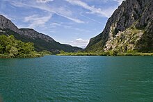
Cetina flows through rocky, karst terrain.
|
|
| Country | Croatia |
| Basin features | |
| Main source | Dinara |
| River mouth | Adriatic Sea |
| Basin size | 1,463 km2 (565 sq mi) |
| Physical characteristics | |
| Length | 101 km (63 mi) |
Cetina (pronounced [t͡sɛ̌tina]) is a river in southern Croatia. It has a length of 101 km (63 mi) and its basin covers an area of 1,463 km2 (565 sq mi). From its source, Cetina descends from an elevation of 385 metres (1,263 ft) above sea level to the Adriatic Sea. It is the most water-rich river in Dalmatia.
Cetina has its source in the northwestern slopes of Dinara. Rising from a spring at Milasevo near a small village called Cetina, 7 kilometres (4.3 mi) north of Vrlika, it flows 101 kilometres (63 mi) to the Adriatic Sea. A large artificial lake begins near Vrlika, the Peruća Lake, which was created by a dam some 25 kilometres (16 mi) downstream. Cetina then passes into the lower portion of the Sinj karst field, through the city of Sinj. After that it runs eastward, through the city of Trilj and then back westward around the Mosor mountain, before flowing into the Adriatic in the city of Omiš.
Apart from its visible basin, the Cetina also receives a lot of water from the west Bosnian karst field via underground routes. Its lower course begins from the Gubavica Falls, at 49 metres (161 ft) above sea level, near the village of Zadvarje, 20 kilometres (12 mi) from Omiš. Here it leaves its canyon and flows into a valley which has nevertheless retained something of the appearance of a canyon.
The latter portion of Cetina and its relatively large drop in elevation was used to build several substantial hydroelectric power plants. Its water is also bottled as Cetina.
The total drainage area of the catchment is around 12,000 km2, and the annual discharge is around 105 m2s−1 as a consequence of a mean annual rainfall of 1380 mm.
...
Wikipedia
