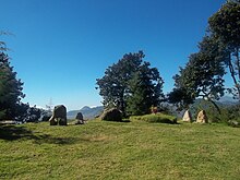
Cerro Quiac

Cerro Quiac occupies the summit of a hill overlooking Cantel
|
|
| Alternative names | K'iaq K'iaqb'al |
|---|---|
| Geographical range | Guatemalan Highlands |
| Period | Maya |
| Type site | Archaeological |
Cerro Quiac (Spanish pronunciation: [ˈsero kiˈak]) (K'iaq [kˀiˈaq] and K'iaqb'al [kˀiaqˈɓal] in the K'iche language) is a small Maya archaeological site located at an altitude of 2,635 metres (8,645 ft), overlooking the Plains of Urbina in the Guatemalan Highlands. When investigated in 1970 it had five stone sculptures, by 1977 only four were left. The sculptures included figures and geometric decoration. The site is still used for contemporary Maya rituals. Cerro Quiac is located in the northeast of the municipality of Cantel, within the boundaries of the hamlet of Chirijquiac.
Cerro Quiac contains two small groups of pre-Columbian architecture. An ethnohistoric document from the early Colonial period describes the site as a fortress founded by the Mam Maya, who were subsequently driven from the area by K'iche' expansion. Cerro Quiac has been dated to the Early Postclassic period of Mesoamerican chronology (approximately 900–1200 AD). Local K'iche' folklore holds that the archaeological site was a training ground for K'iche' warriors, and that the K'iche' hero Tecun Uman died upon the hill.
The name of the hill is variously said to be derived either from the K'iche' word k'iaq, meaning "flea", or from the name of a small black flower that grows on the hill.Cerro means "hill" in Spanish. The name k'iaqb'al for the archaeological site means "place of throwing/shooting".
The site is situated to the south of the Plains of Urbina, 2 kilometres (1.2 mi) east of the Samala River, upon a prominent hill that is visible for approximately 4 kilometres (2.5 mi) in each direction. The summit of the hill is covered with pine forest. The hilltop consists of a 100-metre (330 ft) long ridge, varying in width from 20 to 100 metres (66 to 328 ft). The hill is steep-sided, with the easiest approach from the northeast, the direction furthest from the pre-Columbian remains. The western portion of the ridge is the highest, rising 160 metres (520 ft) above the valley floor; some 60 metres (200 ft) higher than the rest of the hilltop.
...
Wikipedia
