Centre, Alabama
| Centre, Alabama | |
|---|---|
| City | |

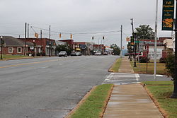
Downtown Centre
|
|
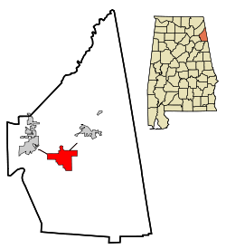
 Location in Cherokee County and the state of Alabama |
|
| Coordinates: 34°9′33″N 85°40′29″W / 34.15917°N 85.67472°W | |
| Country | United States |
| State | Alabama |
| County | Cherokee |
| Government | |
| • Type | Mayor/Council |
| • Mayor | Tony Wilkie |
| Area | |
| • Total | 11.5 sq mi (29.9 km2) |
| • Land | 11.4 sq mi (29.6 km2) |
| • Water | 0.08 sq mi (0.2 km2) |
| Elevation | 663 ft (202 m) |
| Population (2010) | |
| • Total | 3,489 |
| • Density | 305/sq mi (117.8/km2) |
| Time zone | Central (CST) (UTC-6) |
| • Summer (DST) | CDT (UTC-5) |
| ZIP code | 35960 |
| Area code(s) | 256 |
| FIPS code | 01-13648 |
| GNIS feature ID | 0115902 |
| Website | www |
Centre is a city in Cherokee County, Alabama, United States. At the 2010 census the population was 3,489. The city is the county seat of Cherokee County and is part of the Gadsden, Alabama Metropolitan Statistical Area.
Cherokee County was created on January 9, 1836, and named for the Cherokee people who once lived in the area. The famous Cherokee chief Pathkiller lived in Turkeytown near the present town of Centre. In 1836 the newly founded town of Cedar Bluff became the county seat, but in 1844 the county seat was moved to the more centrally located town of Centre. The name was chosen, and carries the British English spelling, because of this central location in the county. In 2011, Centre began allowing the sale of alcoholic beverages, and is no longer a dry city.
Centre is located slightly west of the center of Cherokee County at 34°9'33.052" North, 85°40'29.071" West (34.159181, -85.674742). The city limits extend north to the south shore of Weiss Lake on the Coosa River.
According to the U.S. Census Bureau, the city has a total area of 11.5 square miles (29.9 km2), of which 11.4 square miles (29.6 km2) is land and 0.08 square miles (0.2 km2), or 0.81%, is water.
As of the census of 2010, there were 3,489 people, 1,426 households, and 880 families residing in the city. The population density was 305 inhabitants per square mile (118/km2). There were 1,690 housing units at an average density of 147 per square mile (57/km2). The racial makeup of the city was 87.0% White, 9.9% Black or African American, 0.4% Native American, 0.3% Asian, 0.3% from other races, and 2.1% from two or more races. 1.2% of the population were Hispanic or Latino of any race.
...
Wikipedia
