Centerville, Crawford County, Pennsylvania
| Centerville, Crawford County, Pennsylvania |
|
|---|---|
| Borough | |

Centerville United Methodist Church
|
|
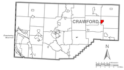
 Location of Centerville in Crawford County |
|
| Location of Centerville in Pennsylvania | |
| Coordinates: 41°44′7″N 79°45′16″W / 41.73528°N 79.75444°WCoordinates: 41°44′7″N 79°45′16″W / 41.73528°N 79.75444°W | |
| Country | United States |
| State | Pennsylvania |
| County | Crawford County |
| Founded | 1812 |
| Area | |
| • Total | 1.8 sq mi (4.6 km2) |
| • Land | 1.8 sq mi (4.6 km2) |
| • Water | 0.0 sq mi (0.0 km2) |
| Elevation | 1,308 ft (399 m) |
| Population (2010) | |
| • Total | 218 |
| • Density | 123/sq mi (47.5/km2) |
| Time zone | EST (UTC-4) |
| • Summer (DST) | EDT (UTC-5) |
| Area code(s) | 814 |
Centerville is a borough in Crawford County, Pennsylvania, United States. The population was 218 at the 2010 census. It was established in 1812.
Centerville is located in eastern Crawford County at 41°44′11″N 79°45′39″W / 41.73639°N 79.76083°W (41.736376, -79.760965). It is bordered by Rome Township to the north, east, and south; by Steuben Township to the southwest; and by Athens Township to the west.
According to the United States Census Bureau, the borough has a total area of 1.8 square miles (4.6 km2), all of it land.Oil Creek, a south-flowing tributary of the Allegheny River, runs through the west side of town; the East Branch enters the borough from the northeast and joins the main creek west of the borough center, which is situated on a ridge that rises between the two creeks.
Pennsylvania Route 8 passes through Centerville, leading north 12 miles (19 km) to Union City and south 9 miles (14 km) to Titusville.
As of the census of 2000, there were 247 people, 99 households, and 67 families residing in the borough. The population density was 138.3 people per square mile (53.3/km²). There were 109 housing units at an average density of 61.0/sq mi (23.5/km²). The racial makeup of the borough was 98.79% White, 0.40% Asian, and 0.81% from two or more races.
...
Wikipedia

