Celaque Mountain National Park
| Celaque National Park | |
|---|---|
|
IUCN category II (national park)
|
|

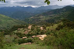
San Isidro, a small town located in Celaque's mountains
|
|
| Location | Lempira Department, Honduras |
| Coordinates | 14°32′08″N 88°42′26″W / 14.53556°N 88.70722°WCoordinates: 14°32′08″N 88°42′26″W / 14.53556°N 88.70722°W |
| Area | 266.4 km2 (102.9 sq mi) |
| Established | 5 August 1987 |
Celaque National Park (formally in Spanish, Parque Nacional Montaña de Celaque) is a national park in Lempira Ocotepeque and Copán, western Honduras. It was established on 5 August 1987 and covers an area of 266.31 square kilometres. It includes Honduras’ tallest peak, called Cerro Las Minas or Pico Celaque, which reaches approximately 2,870 metres (9,416 ft) above mean sea level. It has an elevation ranging from 975 to 2,870 metres (3,199 to 9,416 ft). Celaque’s terrain is very rugged, two-thirds of the area has a slope greater than 60 degrees. The park is classified as a cloud forest with a mean precipitation of 1,600 mm at lower altitudes and a mean of 2,400 mm at higher altitudes. The word celaque is reputed to mean caja de aguas ("box of water(s)") in the local, but now extinct, indigenous Lenca language. Celaque’s nine rivers supplies water to 120 villages nearby including the district capital of Gracias. Celaque is high in biodiversity and is home to pumas, ocelots and Bolitoglossa celaque, an endangered plethodontid salamander found only in the mountains of Celaque.
Between 1970-1980 The Honduran Forestry Development Corporation (HFDC) lead intense logging throughout Celaque’s peaks. The result was a loss in biodiversity and vital resources to the communities. However, logging was not the only cause of loss of forests. The communities inside the park’s perimeters have created open forest patches due to small-scale farming. The people of La Campa, a town close by, grew nervous and formed a grassroots organization to try to stop the logging. Their goal was met in 1987 when the National Congress of Honduras made Celaque a national park. By forming the park, some 266 square kilometres (65,730 acres) were nationally protected from logging, agriculture, outside incursion and market-related forestry exploitation.
...
Wikipedia

