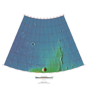
Cebrenia quadrangle

Map of Cebrenia quadrangle from Mars Orbiter Laser Altimeter (MOLA) data. The highest elevations are red and the lowest are blue.
|
|
| Coordinates | 47°30′N 210°00′W / 47.5°N 210°WCoordinates: 47°30′N 210°00′W / 47.5°N 210°W |
|---|---|
| Eponym | Land of Cebrenia near Troy |
The Cebrenia quadrangle is one of a series of 30 quadrangle maps of Mars used by the United States Geological Survey (USGS) Astrogeology Research Program. The quadrangle is located in the northeastern portion of Mars’ eastern hemisphere and covers 120° to 180° east longitude (180° to 240° west longitude) and 30° to 65° north latitude. The quadrangle uses a Lambert conformal conic projection at a nominal scale of 1:5,000,000 (1:5M). The Cebrenia quadrangle is also referred to as MC-7 (Mars Chart-7). It includes part of Utopia Planitia and Arcadia Planitia. The southern and northern borders of the Cebrenia quadrangle are approximately 3,065 km (1,905 mi) and 1,500 km (930 mi) wide, respectively. The north to south distance is about 2,050 km (1,270 mi) (slightly less than the length of Greenland). The quadrangle covers an approximate area of 4.9 million square km, or a little over 3% of Mars’ surface area.
Cebrenia is a telescopic albedo feature centered on 50° N and 150° E on Mars. The feature is named after Cebrenia, a country near ancient Troy. The name was approved by the International Astronomical Union (IAU) in 1958.
The quadrangle's prominent features are the large craters Mie and Stokes, a volcano, Hecates Tholus, and a group of mountains, Phlegra Montes. This area is a flat, smooth plain for the most part, so the relatively large craters Mie and Stokes really stand out. The Galaxias Region has an area of chaos, where the ground seems to have collapsed.
Viking II (part of Viking program) landed near Mie on September 3, 1976. Its landing coordinates were 48° N and 226° W.
The sky would be a light pink. The dirt would also appear pink. The surface would be uneven; the soil would be formed into troughs. Large rocks would be spread about. Most of the rocks are similar in size. Many of the rocks would have small holes or bubbles on their surfaces caused by gas escaping after the rocks came to the surface. Some boulders would show erosion due to the wind. Many rocks would appear to be perched, as if wind removed much of the soil at their bases. In the winter snow or frost would cover most of the ground. There would be many small sand dunes that are still active. The wind speed would typically be 7 meters per second (16 miles per hour). There would be a hard crust on the top of the soil similar to a deposit, called caliche which is common in the U.S. Southwest. Such crusts are formed by solutions of minerals moving up through soil and evaporating at the surface. Scientists, in a September, 2009 article in the journal Science, have asserted that if Viking II only dug four (4) inches deeper, it would have reached a layer of almost pure ice.
...
Wikipedia
