Causeway Street Elevated
| Causeway Street Elevated | |
|---|---|

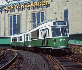
An outbound Green Line train on the Causeway Elevated in front of Boston Garden. The photo dates to between 1989 (Brigham Circle Line restored to Heath Street) and 1998 (Boston Garden demolished).
|
|
| Overview | |
| Type | elevated railway |
| System | Massachusetts Bay Transportation Authority |
| Status | demolished |
| Locale | Boston, Massachusetts, United States |
| Services | Green Line |
| Operation | |
| Opened | June 1, 1912 |
| Closed | June 25, 2004 |
| Character | streetcar services |
| Technical | |
| Track gauge | 4 ft 8 1⁄2 in (1,435 mm) standard gauge |
The Causeway Street Elevated was an elevated section of the MBTA Green Line light rail system in Boston, Massachusetts, located in the area near North Station. It was in operation from 1912 until 2004, when it was replaced with a new tunnel and underground station on a slightly different alignment.
The Causeway Street Elevated began at the Canal Street Incline in parallel with the Charlestown Elevated tracks, and after "splitting" away from it just south of Boston Garden, turned southwest above Causeway Street with an elevated station at North Station in front of the Boston Garden, and then turned northwest above Lowell Street, before joining the Lechmere Viaduct at Leverett Circle. It was a two-track structure on steel girders, similar to the Charlestown Elevated, Atlantic Avenue Elevated, and Washington Street Elevated, which were opened between 1901 and 1909.
The Causeway Street Elevated was one of the last pieces of elevated line constructed in Boston, and, except for a short section remaining at Lechmere, was the last section in service. Although initial plans had called for the Cambridge-Dorchester Line to be constructed as an elevated, the Causeway Street Elevated was the only elevated in Boston not part of the Main Line Elevated.
When the Tremont Street Subway fully opened in 1898, surface cars entering the subway from East Cambridge had to cross Craigie's Bridge and proceed on surface streets to the Canal Street Incline. The trip from Lechmere Point over the bridge was slow and prone to heavy traffic delays. On June 20, 1907, construction began on one mile of elevated track connecting the Canal Street Incline to East Cambridge. The project's centerpiece was the 1,700-foot (520 m) arched Lechmere Viaduct crossing the Charles River; other sections included a short elevated in East Cambridge and an elevated line above Causeway Street connecting the viaduct to the Canal Street Incline. The first streetcars crossed the new bridge and the Causeway Street Elevated in revenue service on June 1, 1912, shortening the ten-minute trip from Lechmere Square to the subway to just three minutes.
...
Wikipedia
