Cauca Valley montane forests
| Cauca Valley montane forests (NT0109) | |
|---|---|

|
|
| Ecology | |
| Realm | Neotropical |
| Biome | Tropical and subtropical moist broadleaf forests |
| Bird species | >500 |
| Mammal species | 120 |
| Geography | |
| Area | 32,412 km2 |
| Countries | Colombia |
| Coordinates | 4°50′20″N 75°37′52″W / 4.839°N 75.631°WCoordinates: 4°50′20″N 75°37′52″W / 4.839°N 75.631°W |
| Climate type | Af: equatorial, fully humid |
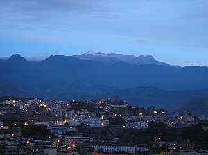
The Cauca Valley montane forests (NT0109) is an ecoregion in western Colombia. It covers the sides of the Cauca Valley, which runs from south to north between the Central and Western Ranges (cordilleras) of the Colombian Andes. The ecoregion is home to very diverse fauna and flora, due in part to its varied elevations and climates, in part to its position near the isthmus of Panama, the route along which North American species invaded South America and then diversified as they moved to the upper parts of the Andes. Little of the original habitat remains at lower levels, but higher up there are sizeable blocks of forest, some of which ate protected.
The Cauca Valley runs from south to north between the Cordillera Central and Cordillera Occidental of the Colombian Andes. It has an area of 3,211,585 hectares (7,936,000 acres). The ecoregion covers both sides of the Cauca River valley, above the narrow strip of Cauca Valley dry forests that runs along the river. On the highest land of the cordilleras the ecoregion gives way to Northern Andean páramo. It transitions to the west into the Northwestern Andean montane forests ecoregion, and on the east into the Magdalena Valley montane forests. In the extreme north, where the river enters the Caribbean lowlands, the ecoregion transitions into the Magdalena-Urabá moist forests ecoregion.
The Cordillera Central to the east of the Cauca Valley started to form in the late Paleozoic (541–252 Ma) on the western edge of a miogeocline, and was still low in the Cretaceous (145–66 Ma). The Cordillera Occidental to the west started to form at the end of the Mesozoic (252–66 Ma). The configuration of three Andean cordilleras in Colombia separated by two large valleys resulted from folding in the Miocene 23–5.3 million year ago (Ma). The mountains rose to the present elevations in the Pliocene (5.3–2.6 Ma) and (2.6 Ma to 11,700 years ago).
...
Wikipedia
