Catterick Camp
| Catterick Garrison | |
|---|---|
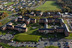
  Single Living Accommodation (SLA) blocks at Catterick. |
|
| Catterick Garrison shown within North Yorkshire | |
| Population | 13,000 |
| OS grid reference | SE180980 |
| Civil parish | |
| District | |
| Shire county | |
| Region | |
| Country | England |
| Sovereign state | United Kingdom |
| Post town | CATTERICK GARRISON |
| Postcode district | DL9 |
| Dialling code | 01748 |
| Police | North Yorkshire |
| Fire | North Yorkshire |
| Ambulance | Yorkshire |
| EU Parliament | Yorkshire and the Humber |
| UK Parliament | |
Catterick Garrison is a major garrison and town three miles (4.8 km) south of Richmond in the Richmondshire district of North Yorkshire, England. It is the largest British Army garrison in the world with a population of around 13,000 and measuring over 2,400 acres, however under plans announced by the Ministry of Defence (MoD) in November 2005, the population of Catterick Garrison is expected to grow to over 25,000 by 2020, making it the largest population centre in the local area.
The siting of the garrison was first recommended by Robert Baden-Powell who founded the Scouting movement in 1908 whilst he, as Inspector-General of Cavalry, was based at the army barracks—at that time located in Richmond Castle. On 12 August 1914, the order was issued for the construction of the camp, following the outbreak of the Great War. The original intention for Catterick was to be a temporary camp to accommodate two complete divisions with around 40,000 men in 2,000 huts. The base was originally named Richmond Camp until being changed to Catterick Camp in 1915, later modified to Catterick Garrison. After serving as a prisoner of war camp at the end of the Great War, the idea to make Catterick a permanent military barracks was first suggested after the partitioning of Ireland in 1921, the required land was purchased and building plans were put forward in 1923. Construction was undertaken by John Laing & Son and by the mid-1930s most of the camp's facilities were complete. During the Second World War the camp was once again used to house prisoners of war.
The town lies in the Richmondshire district of North Yorkshire, within the Central Richmondshire electoral division of North Yorkshire County Council and divided between the Hipswell and Scotton wards of Richmondshire District Council. The town is divided between two civil parishes. The southern part of the town, south of a small stream known as Leadmill Gill, is in the civil parish of Scotton. The northern part forms the greater part of the civil parish of Hipswell. Each parish has its own parish council.
...
Wikipedia

