Catacamas
|
Catacamas Cata |
|
|---|---|
| Municipality | |

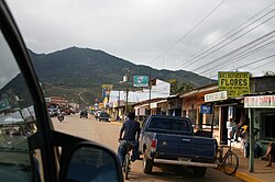
A street scene in central Catacamas -the 'Mirador de la Cruz' is visible in the background
|
|
| Coordinates: 14°48′N 85°54′W / 14.800°N 85.900°WCoordinates: 14°48′N 85°54′W / 14.800°N 85.900°W | |
| Country |
|
| Department | Olancho |
| Founded | 24 January 1898 |
| Area | |
| • Municipality | 7,173.89 km2 (2,769.85 sq mi) |
| Elevation | 450 m (1,480 ft) |
| Population (2015) | |
| • Municipality | 122,185 |
| • Density | 17/km2 (44/sq mi) |
| • Urban | 44,198 |
| Climate | Aw |
| Website | Official website |
Catacamas is a municipality in the Olancho Department of Honduras.
It is the largest municipality in Central America in terms of area.
Catacamas, called the Florida City by the great poet and writer Froylán Turcios, extends over a vast plain irrigated by the Rio Guayape in the heart of the luxuriant department of Olancho.
The city is situated 210 km. north-east of the Honduran capital, Tegucigalpa, and is easily accessible by paved road. Catacamas has historically been characterised by the hospitality, resilience, and progressive spirit of its people, as well as its rich natural setting, which is suitable for both agricultural and forest production.
It is located in a valley 450 meters above sea level. The North White Stone Mountain, part of Agalta Mountains National Park, is located near the city, which is home to a variety of botanical species such as conifers, broadleaf plants, and some 80 varieties of orchids, as well as a rich fauna, including wild cats and the quetzal.
To the north and west are the mountains "Cerro de la Cruz" and the hill "El Cuartel", among others, where you achieve the best panoramic views of the city, including the sports centre and cultural park "Ramón Díaz López".
Approximately five km to the east of Catacamas, one can find the world-famous Talgua Caves (Cuevas de Talgua) discovered in 1935. A recent discovery in the caves is that of the "Glowing Skulls," Pech Indian skeletons from approximately three thousand years ago.
About 6 km to the south of Catacamas runs the Guayape gold, which forms the river Guayambre Patuca, the second longest river in Honduras, after the Segovia. Between the two rivers stretches the Cordillera Entre Ríos, which is part of the Municipality of Catacamas.
Catacamas and Olancho have many characteristics in common: they are the municipality and the largest department of Honduras. Catacamas’ area is 7228.5 square kilometres.
The city of Catacamas is located at 14°54'04" north latitude and 85°, 55', 31", Meridian Grenwich. Gualaco lies to the north, San Esteban and Dulce Nombre de Culmí to the south with Patuca and Las Trojes, to the east, Dulce Nombre de Culmí and the department of Jinotega, Nicaragua, and west to Santa María del Real, San Francisco de Becerra and Juticalpa. The Talgua River runs to the east of the town, before joining the Guayape.
...
Wikipedia

