Carol City (FL)
| Carol City | |
|---|---|
| Neighborhood of Miami Gardens | |
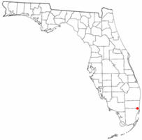
 Location in the state of Florida |
|
| Coordinates: 25°56′32″N 80°16′12″W / 25.94222°N 80.27000°WCoordinates: 25°56′32″N 80°16′12″W / 25.94222°N 80.27000°W | |
| Country | United States |
| State | Florida |
| County | Miami-Dade |
| City | Miami Gardens |
| Area | |
| • Total | 7.7 sq mi (20.0 km2) |
| • Land | 7.6 sq mi (19.7 km2) |
| • Water | 0.1 sq mi (0.3 km2) |
| Population (2010) | |
| • Total | 61,233 |
| • Density | 8,057.0/sq mi (3,108.0/km2) |
| Time zone | Eastern (EST) (UTC-5) |
| • Summer (DST) | EDT (UTC-4) |
| ZIP codes | 33055-33056 |
| Area code(s) | 305 |
| FIPS code | 12-10650 |
Carol City is a neighborhood in Miami Gardens, Florida, United States. The population was 61,233 at the 2010 census.
In the 1960s, much of Carol City included farmland. As the decades progressed, many people in Miami Gardens blamed the public housing in the area, including the developments around Carol City High School, of importing crime and recreational drugs into the area. In 2007, Mayor Shirley Gibson of Miami Gardens announced she would not allow any more public housing projects to open in Miami Gardens.
Carol City is located at 25°56′32″N 80°16′12″W / 25.94222°N 80.27000°W (25.942121, -80.269920). According to the United States Census Bureau, the community has a total area of 20.0 km² (7.7 mi²). 19.7 km² (7.6 mi²) of it is land and 0.3 km² (0.1 mi²) of it (1.42%) is water.
As of the census of 2000, there were 59,443 people, 16,402 households, and 14,089 families residing in the community. The population density was 3,012.0/km² (7,796.0/mi²). There were 17,049 housing units at an average density of 863.9/km² (2,236.0/mi²). The racial makeup of the CDP was 52.10% African American, 38.11% White (6.4% were Non-Hispanic White,). 0.55% Asian, 0.19% Native American, 0.04% Pacific Islander, 5.53% from other races, and 3.48% from two or more races. Hispanic or Latino of any race were 42.00% of the population.
...
Wikipedia
