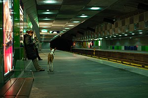
Carl Berners plass (station)
 |
|
| Location |
Carl Berners plass, Helsfyr, Oslo Norway |
| Coordinates | 59°55′32″N 10°46′42″E / 59.92556°N 10.77833°ECoordinates: 59°55′32″N 10°46′42″E / 59.92556°N 10.77833°E |
| Elevation | 50.3 m (165 ft) |
| Owned by | Sporveien |
| Operated by | Sporveien T-banen |
| Line(s) | Grorud Line |
| Distance | 3.3 km (2.1 mi) from Stortinget |
| Connections |
Tram: 17 Grefsen – Rikshospitalet Bus: 20 Galgeberg – Skøyen 21 Helsfyr – Aker Brygge 31 Snarøya – Tonsenhagen |
| Construction | |
| Structure type | Underground |
| History | |
| Opened | 1 February 1923 (tram) 16 October 1966 (metro) |
Carl Berners plass is an underground rapid transit station located on the Grorud Line of the Oslo Metro, and a tram stop on the Sinsen Line of the Oslo Tramway. The square also has a bus stop for lines 20, 21, 31 and 33. Located at Helsfyr in Oslo, Norway, the area has a mixture of apartment buildings and small businesses. The station is the first metro station on the Grorud Line after it branches off from the shared Common Tunnel. North of the station, the Ring Line branches off from the Grorud Line. The station is served by line 5 of the metro and Line 17 of the tramway, with four hourly departures during regular hours. The tram operates every 10 minutes during regular hours.
The square was taken into use as a tram stop on 1 February 1923. The station took the name after the square, which is again named for the 18th and early 19th-century politician Carl Berner. From 6 February 1949, Line 20 of the Oslo trolleybus started serving the square. From 2 January 1955, the Rodeløkka Line of the tramway was rerouted to run via Carl Berners plass, although it was closed again on 1961. The underground metro station opened on 16 October 1966, and the trolleybus service was replaced by diesel buses in 1968. From 20 August 2006, the metro station also started serving the Ring Line (Line 5).
Carl Berners plass is a combined metro, tram and bus station located at the square Carl Berners plass, from which it takes its name. The underground station is actually located a couple of hundred meters off the square, with ground-level entrances on either side of the heavily trafficked Grenseveien as that road ascends from the square towards the east. The underground metro station is on the Grorud Line, and is located 3.3 kilometers (2.1 mi) from Stortinget in the city center. The tracks are 50.3 meters (165 ft) above sea level. The area around the station is mostly dense residential and small businesses. South of the station is Tøyen Park.
...
Wikipedia
