Cardamom Range
| Cardamom Mountains | |
|---|---|

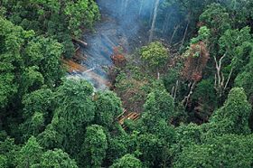
Aerial view of an illegal logging camp in the Cardamom Mountains in Koh Kong Province
|
|
| Highest point | |
| Peak | Phnom Aural |
| Elevation | 1,813 m (5,948 ft) |
| Dimensions | |
| Length | 300 km (190 mi) NW/SE |
| Width | 70 km (43 mi) NE/SW |
| Geography | |
| Country | Cambodia and Thailand |
| Range coordinates | 12°00′N 103°15′E / 12.000°N 103.250°ECoordinates: 12°00′N 103°15′E / 12.000°N 103.250°E |
| Geology | |
| Age of rock | Cambrian |
| Type of rock | Metaconglomerate |
The Krâvanh Mountains, literally the "Cardamom Mountains" (Khmer: ជួរភ្នំក្រវាញ, Chuor Phnom Krâvanh; Thai: ทิวเขาบรรทัด, Thio Khao Banthat, pronounced [tʰīw kʰǎw bān.tʰát]), is a mountain range in the south west of Cambodia and Eastern Thailand.
The silhouette of the Cardamom Mountains appears in the provincial seal of Trat Province in Thailand.
The mountain range extends along a southeast-northwest axis from Koh Kong Province on the Gulf of Thailand to the Veal Veang District in Pursat Province, and is extended to the southeast by the Dâmrei (Elephant) Mountains. The northwestern end of the range in Chanthaburi Province, Thailand, appears also as the 'Soi Dao Mountains' (Khao Soi Dao) and as 'Chanthaburi Range' in some maps.
Dense tropical rainforest prevails on the wet western slopes which annually receive from 150 to 200 inches (3,800–5,000 mm) of rainfall. By contrast only 40 to 60 inches (1,000 to 1,500 mm) fall in places like Kirirom National Park on the wooded eastern slopes in the rain shadow facing the interior Cambodian plain. On the eastern slopes cardamom and pepper are still grown commercially.
The highest elevation of the Cardamom Mountains is Phnom Aural at 1,813 metres (5,948 ft) high. This is also Cambodia's highest peak. Phnom Samkos (1,717 m), Phnom Tumpor (1,516 m) and Phnom Kmoch (1,220 m) are other important summits.
...
Wikipedia

