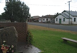
Caragabal
|
Caragabal New South Wales |
|
|---|---|

War memorial, hall, ex-bank and pub
|
|
| Coordinates | 33°50′0″S 147°45′0″E / 33.83333°S 147.75000°ECoordinates: 33°50′0″S 147°45′0″E / 33.83333°S 147.75000°E |
| Population | 214 (2011 census) |
| Postcode(s) | 2810 |
| Elevation | 232 m (761 ft) |
| Location | |
| LGA(s) | Weddin Shire |
| State electorate(s) | Cootamundra |
| Federal Division(s) | Hume |
Caragabal (/kəˈræɡəbʊl/ kə-RAG-ə-buul) is a village and locality in New South Wales 413 kilometres west of Sydney. It is situated on flat country in the Weddin Shire, just beyond where the last slopes of the Great Dividing Range meet the plains of the Central West. The Barbingal Creek runs, after rain, along the south edge of the village parallel to the Mid-Western Highway.
The village of Quandialla is 22 kilometres to the south. The towns of Grenfell, Forbes and West Wyalong are within 45 minutes' drive.
214 people were recorded at the 2011 census for the Caragabal area – 117 males and 97 females. An increase from the 2006 figure of 199. 66% of employed persons were in "sheep, beef cattle and grain farming". Recent decline in population is evidenced by the number of electors casting ballots at Caragabal Public School; 180 in 1998; 151 in 2004, and 127 in 2007, with a slight increase to 136 in 2011. Only 14 students were enrolled at the School in 2012, compared to 118 in 1958.
Permanent white settlement in this part of Wiradjuri country commenced in 1835, when colonial surgeon Andrew Gibson took up extensive grazing holdings ('runs') in the area at; Bogo Bogolong (45,000 ha), Wheogo (13,680ha) and Bland (17,920ha). Gibson's Run at Bland was reduced in size in about 1848 and renamed Caragabal Station.
...
Wikipedia

