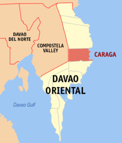
Caraga, Davao Oriental
| Caraga | |
|---|---|
| Municipality | |
 Map of Davao Oriental with Caraga highlighted |
|
| Location within the Philippines | |
| Coordinates: 07°20′N 126°34′E / 7.333°N 126.567°ECoordinates: 07°20′N 126°34′E / 7.333°N 126.567°E | |
| Country | Philippines |
| Region | Davao Region (Region XI) |
| Province | Davao Oriental |
| District | 1st District of Davao Oriental |
| Founded | 1861 |
| Incorporated | July 15, 1903 |
| Barangays | 17 |
| Government | |
| • Mayor | Alicia Benitez Mori |
| Area | |
| • Total | 642.70 km2 (248.15 sq mi) |
| Population (2015 census) | |
| • Total | 40,379 |
| • Density | 63/km2 (160/sq mi) |
| Time zone | PST (UTC+8) |
| ZIP code | 8203 |
| IDD : area code | +63 (0)87 |
| Income class | 1st municipal income class |
| 112504000 | |
| Electorate | 22,768 voters as of 2016 |
Caraga is a 1st class municipality in the province of Davao Oriental, Philippines. According to the 2015 census, it has a population of 40,379 people.
The municipality is located 254 kilometres (158 mi) from Davao City, the regional center of Region XI, and 84 kilometres (52 mi) from Mati, the capital town of the province of Davao Oriental on the island of Mindanao. It lies along the eastern coast of this province, facing the Pacific Ocean. It is bounded in the north by the Municipality of Baganga in the south by the municipality of Manay, in the west by the Municipality of New Bataan, Compostela Valley Province, and on the east by the Pacific Ocean. Pusan point of Barangay Santiago is the easternmost point of the Philippines.
Caraga coastline is irregular and the municipality is traversed by the two rivers: Caraga River in the south and Manurigao River in the north.
Caraga has a total land area 64,270 hectares (158,800 acres), representing 12.45% of the total land area of the Province of Davao Oriental, and seventeen (17) barangays. Barangay Pichon occupies the largest land area with 16,300 hectares (40,000 acres) which are 25.35% of the total land area of the municipality. Barangay D.L Balante, which is located in the south-west of Barangay Poblacion, is the smallest barangay with a land area of 975 hectares (2,410 acres) or 1.51% of the total land area of this municipality.
Caraga is politically subdivided into 17 barangays.
The official founding of the town was in 1861 along with Mati, making it one of the oldest towns of the province of Davao Oriental.
The etymology of the word "Caraga" is said to have originated from the native word "Kalag" which means "spirit of soul". Hence, the whole Provincia de Caraga of 1622 was called "region de gente animosa", that is "region of spirited men". This being "spirited men and women" is grounded on its cultural, religious and political background. With culture, Caragans were spirited in view of their closeness to nature and attitude towards the creation. With religiosity, Caragans were spirited as to their belief on the spirits of nature (like the trees "balete tree", the rivers and mountains, sun and moon); in fact, they have "anito worship" and "ancestor worship" led by the dancing priestess (balyan) and the singing priestess (catalunan). With primitive politics, Caragans were spirited as they invited a "bagani system" of governance. A "bagani" is like a "warrior" kinglet or datu" who ruled by banditry and by occupation.
...
Wikipedia

