Capitol Hill (Seattle)
| Capitol Hill | |
|---|---|
| Seattle Neighborhood | |

Capitol Hill, as seen from 9th Avenue and Pine street looking east.
|
|
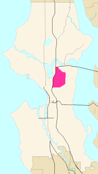
 Map of Capitol Hill's location in Seattle |
|
| Country | United States |
| State | Washington |
| City | Seattle |
| City Council | District 3 |
| Neighborhood Council | East District |
| Police District | East Precinct, E1-3 |
| Established | Annexed to Seattle on Feb. 4, 1886 |
| Founded by | James A. Moore |
| Named for | Potential State Capitol |
| Area | |
| • Total | 1.64 sq mi (4.2 km2) |
| Population | |
| • Total | 32,144 |
| • Density | 20,000/sq mi (7,600/km2) |
| ZIP code | 98102, 98112, 98122 |
Capitol Hill, locally nicknamed "the Hill," is a densely populated residential district in Seattle, Washington, United States. It is one of the city's most prominent nightlife and entertainment districts and is the center of the city's counterculture communities.
Capitol Hill is situated on a steep hill just east of the city's downtown central business district.
The neighborhood is bounded by Interstate 5 (I-5) to the west, beyond which are Downtown, Cascade, and Eastlake; to the north by State Route 520 and Interlaken Park, beyond which are the Portage Bay and Montlake neighborhoods; to the south by E. Union and E. Madison Streets, beyond which are First Hill and the Central District; and to the east by 23rd and 24th Avenues E., beyond which is Madison Valley.
Capitol Hill's main thoroughfare is Broadway, which forms the commercial heart of the district. Other significant streets are 10th, 12th, 15th, and 19th Avenues, all running north-south, and E. Pine, E. Pike, E. John, E. Thomas, and E. Aloha Streets and E. Olive Way, running east-west. Of these streets, large portions of E. Pike Street, E. Pine Street, Broadway, 15th Avenue, and E. Olive Way are lined almost continuously with streetfront businesses.
The Pike-Pine corridor (the area between Pike and Pine street from Boren Avenue through 15th Street is another main thoroughfare of the neighborhood, full of coffeeshops, bars, restaurants, and other food or music related businesses.
The highest point on Capitol Hill, at 444.5 feet (135.5 m) above sea level, is in Volunteer Park, adjacent to the water tower. Capitol Hill is also responsible for half of Seattle's 12 steepest street grades: 21% on E. Roy Street between 25th and 26th Avenues E. (eastern slope), 19% on E. Boston Street between Harvard Avenue E. and Broadway E. (western slope) and on E. Ward Street between 25th and 26th Avenues E. (eastern slope), and 18% on E. Highland Drive between 24th and 25th Avenues E. (eastern slope), on E. Lee Street between 24th and 25th Avenues E. (eastern slope), and on E. Roy Street between Melrose and Bellevue Avenues E. (western slope).
...
Wikipedia
