Canton Berne
| Kanton Bern Canton de Berne |
||
|---|---|---|
| Canton of Switzerland | ||
|
||
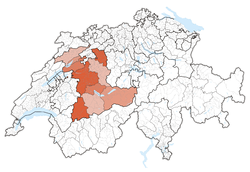
 Location in Switzerland |
||
| Coordinates: 46°50′N 7°37′E / 46.833°N 7.617°ECoordinates: 46°50′N 7°37′E / 46.833°N 7.617°E | ||
| Capital | Bern | |
| Subdivisions | 388 municipalities, 10 districts | |
| Government | ||
| • Executive | Regierungsrat, Conseil exécutif (7) | |
| • Legislative | Grosser Rat, Grand conseil (160) | |
| Area | ||
| • Total | 5,959.44 km2 (2,300.95 sq mi) | |
| Population (12/2015) | ||
| • Total | 1,017,483 | |
| • Density | 170/km2 (440/sq mi) | |
| ISO 3166 code | CH-BE | |
| Highest point | 4,274 m (14,022 ft): Finsteraarhorn | |
| Lowest point | 401.5 m (1,317 ft): Aare at Wynau | |
| Joined | 1353 | |
| Languages | German, French | |
| Website | BE.ch | |
The canton of Bern (German: Kanton Bern, ![]() pronunciation ; French: Canton de Berne) is the second largest of the 26 Swiss cantons by both surface area and population. Located in west-central Switzerland, it borders the canton of Jura and the canton of Solothurn to the north. To the west lie the canton of Neuchâtel, the canton of Fribourg and Vaud. To the south lies the canton of Valais. East of the canton of Bern lie the cantons of Uri, Nidwalden, Obwalden, Lucerne and Aargau.
pronunciation ; French: Canton de Berne) is the second largest of the 26 Swiss cantons by both surface area and population. Located in west-central Switzerland, it borders the canton of Jura and the canton of Solothurn to the north. To the west lie the canton of Neuchâtel, the canton of Fribourg and Vaud. To the south lies the canton of Valais. East of the canton of Bern lie the cantons of Uri, Nidwalden, Obwalden, Lucerne and Aargau.
The canton of Bern is bilingual and has a population (as of 31 December 2015) of 1,017,483. As of 2007[update], the population included 119,930 (or 12.45%) foreigners. The cantonal capital, also the federal capital of Switzerland, is Bern.
Bern joined the Old Swiss Confederation in 1353. Between 1803 and 1814 it was one of the six directorial cantons of the Napoleonic Swiss Confederation.
...
Wikipedia


