Canterbury, New Hampshire
| Canterbury, New Hampshire | ||
|---|---|---|
| Town | ||

Town center: Canterbury United Community Church (L) & Country Store (R)
|
||
|
||
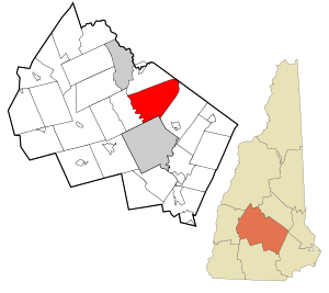
 Location in Merrimack County and the state of New Hampshire. |
||
| Coordinates: 43°20′11″N 71°33′53″W / 43.33639°N 71.56472°WCoordinates: 43°20′11″N 71°33′53″W / 43.33639°N 71.56472°W | ||
| Country | United States | |
| State | New Hampshire | |
| County | Merrimack | |
| Incorporated | 1741 | |
| Government | ||
| • Board of Selectmen | Cheryl Gordon, Chair George Glines Arthur Hudson |
|
| • Town Administrator | Ken Folsom | |
| Area | ||
| • Total | 44.4 sq mi (115.0 km2) | |
| • Land | 43.6 sq mi (112.9 km2) | |
| • Water | 0.8 sq mi (2.1 km2) 1.82% | |
| Elevation | 599 ft (183 m) | |
| Population (2010) | ||
| • Total | 2,352 | |
| • Density | 53/sq mi (20/km2) | |
| Time zone | Eastern (UTC-5) | |
| • Summer (DST) | Eastern (UTC-4) | |
| ZIP code | 03224 | |
| Area code(s) | 603 | |
| FIPS code | 33-09860 | |
| GNIS feature ID | 0873559 | |
| Website | www.canterbury-nh.org | |
Canterbury is a town in Merrimack County, New Hampshire, United States. The population was 2,352 at the 2010 census.
First granted by Lieutenant Governor John Wentworth in 1727, the town was named for William Wake, Archbishop of Canterbury. It was originally a militia timber fort and trading post of Capt. Jeremiah Clough located on a hill near Canterbury Center, where the Pennacook Indians came to trade. The town would be incorporated in 1741. There were several garrison houses or in the area as late as 1758.
According to the United States Census Bureau, the town has a total area of 44.4 square miles (115.0 km2), of which 43.6 square miles (112.9 km2) is land and 0.8 square miles (2.1 km2) is water, comprising 1.82% of the town. The town's highest point is an unnamed summit near Forest Pond and the town's northern border, where the elevation reaches approximately 1,390 feet (420 m) above sea level. Bounded by the Merrimack River on the west, Canterbury is drained on the east by the Soucook River. Canterbury lies fully within the Merrimack River watershed.
As of the census of 2000, there were 1,979 people, 749 households, and 590 families residing in the town. The population density was 45.1 people per square mile (17.4/km²). There were 838 housing units at an average density of 19.1 per square mile (7.4/km²). The racial makeup of the town was 98.59% White, 0.25% African American, 0.25% Asian, 0.05% Pacific Islander, 0.10% from other races, and 0.76% from two or more races. Hispanic or Latino of any race were 0.51% of the population.
...
Wikipedia

