Campton, Kentucky
| Campton, Kentucky | |
|---|---|
| City | |

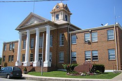
Wolfe County courthouse in Campton
|
|
 Location of Campton, Kentucky |
|
| Coordinates: 37°44′5″N 83°32′54″W / 37.73472°N 83.54833°WCoordinates: 37°44′5″N 83°32′54″W / 37.73472°N 83.54833°W | |
| Country | United States |
| State | Kentucky |
| County | Wolfe |
| Incorporated | March 17, 1870 |
| Government | |
| • Type | City Commission |
| • Mayor | Raymond Banks |
| Area | |
| • Total | 1.1 sq mi (2.9 km2) |
| • Land | 1.1 sq mi (2.8 km2) |
| • Water | 0.0 sq mi (0.1 km2) |
| Elevation | 961 ft (293 m) |
| Population (2010) | |
| • Total | 441 |
| • Density | 400.9/sq mi (152.1/km2) |
| Time zone | Eastern (EST) (UTC-5) |
| • Summer (DST) | EDT (UTC-4) |
| ZIP codes | 41301, 41342 |
| Area code(s) | 606 |
| FIPS code | 21-12358 |
| GNIS feature ID | 0511172 |
Campton is a home rule-class city in and the county seat of Wolfe County, Kentucky, United States. The population was 424 at the 2000 census.
Campton was a camp town with a small creek, swift creek (named after Jonathan Swift of the legend of Swift's silver mine) running through the town. Swift supposedly buried treasure in the area which has never been recovered.
The annual Swift Silver Mine Festival is held on Labor Day weekend each year. It includes a parade and vendors in the downtown area.
Campton is located at 37°44′05″N 83°32′54″W / 37.734689°N 83.548427°W.
According to the United States Census Bureau, the city has a total area of 1.1 square miles (2.8 km2), of which 1.1 square miles (2.8 km2) is land and 0.04 square miles (0.10 km2) (3.57%) is water.
As of the census of 2000, there were 424 people, 196 households, and 117 families residing in the city. The population density was 393.4 people per square mile (151.6/km²). There were 229 housing units at an average density of 212.5 per square mile (81.9/km²). The racial makeup of the city was 99.76% White, and 0.24% from two or more races. Hispanic or Latino of any race were 0.71% of the population.
...
Wikipedia
