Campden Rural District
| Campden | |
|---|---|
 |
|
| Area | |
| • 1911 | 23,726 acres (96.02 km2) |
| • 1931 | 37,658 acres (152.40 km2) |
| Population | |
| • 1901 | 5,441 |
| • 1931 | 8,299 |
| History | |
| • Created | 1894 |
| • Abolished | 1935 |
| • Succeeded by | North Cotswold Rural District, Stratford-on-Avon Rural District |
| Status | Rural district |
| • HQ | Shipston on Stour |
Coordinates: 51°53′06″N 2°08′35″W / 51.885°N 2.143°W
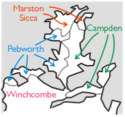
Campden was, from 1894 to 1935, a rural district in the administrative county of Gloucestershire, England. The district lay on the north-eastern boundary of the Gloucestershire, and consisted of three separate areas nearly surrounded by the counties of Warwickshire and Worcestershire. The county and district boundaries were simplified in 1931 and the district was abolished in 1935.
The rural district was created by the Local Government Act 1894 from the part of Shipston on Stour Rural Sanitary District in Gloucestershire. The remainder of Shipston RSD became Shipston on Stour Rural District in Warwickshire. The rural district was named after Chipping Campden and was governed by a directly elected rural district council (RDC), which replaced the rural sanitary authority that had comprised the poor law guardians for the area. Campden RDC continued to hold its meetings in the offices of Shipston Poor Law Union, outside the district.
The rural district lay on the edge of three counties with very irregular boundaries, including a number of detached parishes.
The district initially consisted of two parts: Seven civil parishes formed part of a salient of Gloucestershire surrounded by Warwickshire and Worcestershire:
...
Wikipedia
