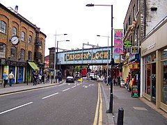
Camden town
| Camden Town | |
|---|---|
 Chalk Farm Road, near where it becomes Camden High Street |
|
| Camden Town shown within Greater London | |
| Population | 24,538 (Camden Town with Primrose Hill and Cantelowes wards 2011) |
| OS grid reference | TQ295845 |
| • Charing Cross | 2.4 mi (3.9 km) SSE |
| London borough | |
| Ceremonial county | Greater London |
| Region | |
| Country | England |
| Sovereign state | United Kingdom |
| Post town | LONDON |
| Postcode district | NW1 NW5 |
| Dialling code | 020 |
| Police | Metropolitan |
| Fire | London |
| Ambulance | London |
| EU Parliament | London |
| UK Parliament | |
| London Assembly | |
Camden Town (![]() i/ˈkæmdən/), often shortened to Camden (ambiguously also used for the much larger London Borough of Camden of which it is the central neighbourhood), is an inner city district of northwest London, 2.4 miles (3.9 km) north of the centre of London. It is one of the 35 major centres identified in the London Plan.
i/ˈkæmdən/), often shortened to Camden (ambiguously also used for the much larger London Borough of Camden of which it is the central neighbourhood), is an inner city district of northwest London, 2.4 miles (3.9 km) north of the centre of London. It is one of the 35 major centres identified in the London Plan.
Laid out as a residential district from 1791 and originally part of the manor of Kentish Town and the parish of St Pancras, London, Camden Town became an important location during the early development of the railways, which reinforced its position on the London canal network. The area's industrial economic base has been replaced by service industries such as retail, tourism and entertainment. The area now hosts street markets and music venues which are strongly associated with alternative culture.
Camden Town is named after Charles Pratt, 1st Earl Camden. His earldom was styled after his estate, Camden Place near Chislehurst in Kent (now in the London Borough of Bromley), formerly owned by historian William Camden. The name, which appears on the Ordnance Survey map of 1822, was later applied to the early 20th century Camden Town Group of artists and the London Borough of Camden, created in 1965.
...
Wikipedia

