Camden, Delaware
| Camden, Delaware | |
|---|---|
| Town | |

1805 Quaker Meetinghouse
|
|
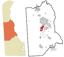
 Location in Kent County and the state of Delaware. |
|
| Location within the state of Delaware | |
| Coordinates: 39°06′48″N 75°32′31″W / 39.11333°N 75.54194°WCoordinates: 39°06′48″N 75°32′31″W / 39.11333°N 75.54194°W | |
| Country | United States |
| State | Delaware |
| County | Kent |
| Area | |
| • Total | 1.9 sq mi (4.8 km2) |
| • Land | 1.9 sq mi (4.8 km2) |
| • Water | 0.0 sq mi (0.0 km2) |
| Elevation | 39 ft (12 m) |
| Population (2010) | |
| • Total | 3,464 |
| • Density | 1,130.9/sq mi (436.6/km2) |
| Time zone | Eastern (EST) (UTC-5) |
| • Summer (DST) | EDT (UTC-4) |
| ZIP code | 19934 |
| Area code(s) | 302 |
| FIPS code | 10-10760 |
| GNIS feature ID | 213746 |
Camden is a town in Kent County, Delaware, United States. It is part of the Dover, Delaware Metropolitan Statistical Area. The population was 3,464 at the 2010 census.
Camden was established in 1783 as a community originally known as Mifflin's Crossroads. The Camden Historic District, Brecknock, Camden Friends Meetinghouse, Star Hill AME Church, and Zion African Methodist Episcopal Church are listed on the National Register of Historic Places.
Camden is located at 39°06′48″N 75°32′31″W / 39.11333°N 75.54194°W (39.1134458, -75.5418687).
According to the United States Census Bureau, the town has a total area of 1.9 square miles (4.9 km2), all land.
Because of the small size of this town, and its even smaller neighbor of Wyoming, the U.S. Postal Service has jointly assigned the towns a single ZIP code, 19934, which is designated as the Camden-Wyoming ZIP code.
...
Wikipedia


