Camden, Arkansas
| Camden, Arkansas | ||
|---|---|---|
| City | ||
| City of Camden | ||

Downtown Camden
|
||
|
||
| Motto: "Star of the River" | ||
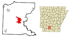
 Location in Ouachita County and the state of Arkansas |
||
| Coordinates: 33°34′15″N 92°50′6″W / 33.57083°N 92.83500°WCoordinates: 33°34′15″N 92°50′6″W / 33.57083°N 92.83500°W | ||
| Country |
|
|
| State |
|
|
| County | Ouachita | |
| Township | Ecore Fabre, Lafayette | |
| Incorporated | 1844 | |
| Government | ||
| • Type | Mayor–Council | |
| • Mayor | Marie Trisollini (I) | |
| • Council | Camden City Council | |
| Area | ||
| • Total | 42.8 km2 (16.6 sq mi) | |
| • Land | 42.6 km2 (16.5 sq mi) | |
| • Water | 0.2 km2 (0.1 sq mi) | |
| Elevation | 62 m (203 ft) | |
| Population (2010) | ||
| • Total | 12,183 | |
| • Density | 307.3/km2 (792.4/sq mi) | |
| Time zone | Central (CST) (UTC-6) | |
| • Summer (DST) | CDT (UTC-5) | |
| ZIP codes | 71701, 71711 | |
| Area code(s) | 870 | |
| FIPS code | 05-10720 | |
| GNIS feature ID | 0076505 | |
| Website | camden |
|
Camden is a city in and the county seat of Ouachita County in the south-central part of the U.S. state of Arkansas.
In 2000, Camden had a population of 13,154, but it lost 7.4 percent of its residents and recorded 12,183 in 2010. The municipality in 2010 was 56 percent African American. Camden is the principal city of the Camden Micropolitan Statistical Area, which includes all of Ouachita and Calhoun counties.
Indigenous peoples of various cultures lived along the rivers of Arkansas for thousands of years and created complex societies. Mississippian culture peoples built massive earthwork mounds along the Ouachita River, beginning circa 1000.
The region was part of French Louisiana from 1682-1762. The Indians who had given their name to the river had died out or moved on by the mid-1700s. The land along the Ouachita River was inhabited by remnants of several Indian tribes, and the river was home to a small population of mostly French hunters, trappers and traders. Then, in 1763, Spain acquired Louisiana by treaty, but the culture remained decidedly French. After the American Revolution, Spanish Governor Bernardo de Gálvez decided to establish a military post on the upper Ouachita as a buffer between US and Spanish territory. He appointed a Frenchman named Jean-Baptiste Filhiol (Don Juan Filhiol) to be the commandant of the new post. In 1782, Filhiol chose an old, established center of trade called Ecore à Fabri (Fabri's Bluff) located high above the Ouachita River at present-day Camden. This was the first attempt at a European settlement on the Ouachita. The nomadic inhabitants had no interest in an agrarian lifestyle, and efforts to attract settlers from elsewhere failed. A few years later, Filhiol moved the Ouachita Post down the river to Prairie des Canots, now Monroe, Louisiana.
...
Wikipedia

