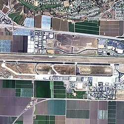
Camarillo Airport
| Camarillo Airport | |||||||||||||||
|---|---|---|---|---|---|---|---|---|---|---|---|---|---|---|---|

2006 USGS photo
|
|||||||||||||||
| Summary | |||||||||||||||
| Airport type | Public | ||||||||||||||
| Owner | County of Ventura | ||||||||||||||
| Location | Camarillo, California | ||||||||||||||
| Elevation AMSL | 77 ft / 23 m | ||||||||||||||
| Coordinates | 34°12′50″N 119°05′40″W / 34.21389°N 119.09444°W | ||||||||||||||
| Runways | |||||||||||||||
|
|||||||||||||||
| Helipads | |||||||||||||||
|
|||||||||||||||
| Statistics (2006) | |||||||||||||||
|
|||||||||||||||
|
Source: Federal Aviation Administration
|
|||||||||||||||
| Aircraft operations | 153,360 |
|---|---|
| Based aircraft | 600 |
Camarillo Airport (ICAO: KCMA, FAA LID: CMA) is a public airport located three miles (5 km) west of the central business district of Camarillo, a city in Ventura County, California, United States. It is roughly equidistant from Los Angeles, CA and Santa Barbara, CA although it is inland. The airport has one runway and exclusively serves privately operated general aviation and executive aircraft with no scheduled commercial service. A separate airfield exists in the southwest quadrant of the airport for exclusive use of Light-Sport Aircraft and Ultralights.
Before 1970, the airport was known as Oxnard Air Force Base.
According to the FAA's National Plan of Integrated Airport Systems for 2007–2011, it is categorized as a reliever airport.
The music video for Anastacia's 2001 hit song "Cowboys & Kisses" was filmed here.
Camarillo Airport was the filming location for an episode of the TV series 24.
Camarillo Airport was originally established in 1942 when the California State Highway Department constructed an auxiliary landing field with a 5,000 ft (1,500 m) runway, which was later extended to 8,000 ft (2,400 m) in 1951 to accommodate what by then had developed into Oxnard Air Force Base.
...
Wikipedia
