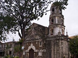
Calumpit, Bulacan
| Calumpit | ||
|---|---|---|
| Municipality | ||

Saint John the Baptist church
|
||
|
||
| Motto: God bless Calumpit | ||
 Map of Bulacan showing the location of Calumpit |
||
| Location within the Philippines | ||
| Coordinates: 14°55′N 120°46′E / 14.92°N 120.77°ECoordinates: 14°55′N 120°46′E / 14.92°N 120.77°E | ||
| Country | Philippines | |
| Region | Central Luzon (Region III) | |
| Province | Bulacan | |
| District | 1st District | |
| Encomienda | November 14, 1571 | |
| Ecclesiastical Town | May 3, 1572 | |
| Civil Town | March 5, 1575 | |
| Founded by |
|
|
| Barangays | 29 | |
| Government | ||
| • Mayor | Jessie P. De Jesus | |
| Area | ||
| • Total | 56.25 km2 (21.72 sq mi) | |
| Population (2015 census) | ||
| • Total | 108,757 | |
| • Density | 1,900/km2 (5,000/sq mi) | |
| • Poverty rate |
|
|
| Time zone | PST (UTC+8) | |
| ZIP code | 3003 | |
| IDD : area code | +63 (0)44 | |
| Income class | 1st class municipality | |
| Electricity | Manila Electric Company | |
| • Consumption | 35.30 million kWh (2003) | |
| Website | www |
|
Calumpit is a first class urban municipality in the province of Bulacan, Philippines. According to the 2015 census, it has a population of 108,757 people.
The name "Calumpit" comes from the tree "Kalumpít" (an indigenous hardwood species similar to apalit and narra, which grows abundantly in front of the St. John the Baptist Parish Church in the Población-Sucol area.
Calumpit was already an established “barangay” under the leadership of Gat Maitim prior to Spanish Conquest of Luzon in started with the Fall of Kingdom of Tondo in June 1571.Other villages exist nearby are Gatbuka,Meyto,Meysulao,Pandukot.Malolos,Macabebe,Hagonoy,Apalit.When Calumpit was hispanized and established as a town with political and geographical entity,they chosen the village of Calumpit as the site of the church and the administrative center the mentioned villages was annexed to the new Town of Calumpit in 1572.
Upon hearing that Kingdom of Tondo was conquered by Martin de Goiti and Juan Salcedo and Rakah Matanda was agreed to join with the Spaniards in May 1571, Bambalito formed a fleet consisting of two thousand natives mostly from Hagonoy and Macabebe. They sailed to Tondo on June 3, 1571 facing Goiti and Salcedo that led to the historic Battle of Bangkusay Channel. Bambalito and the natives were defeated and the conquerors made they way to pacify other villages along Manila bay north of Tondo. In September 1571 Martin de Goiti and Juan Salcedo together with other conquistadors reached Lubao and pacified the villages at the coast of Manila Bay, then in November 14, 1571 they reached Calumpit and Malolos and reported it to Adelantado Miguel Lopez de Legaspi, the first Spanish Governor General of the Philippine Islands constituting them as Encomienda de Calumpit and Encomienda de Malolos, respectively. Encomienda de Calumpit was entrusted to Sargento Juan Moron, one of the conquerors included in Legazpi Expedition. (Blair and Robertson, The Philippine Islands, volume 34, page 304-310, paragraph 3)
No exact details when the Augustinians set their foot in Calumpit but according to the documents, Calumpit had its own parish on May 3, 1572 when Fray Martin de Rada were elected as the new Prior Provincial held at San Augustin Convent. The Augustinian dispatch some missionaries to the different settlements to spread the catholic faith. Calumpit were simultaneously established together with the conventos of Bay Laguna Tondo and Lubao Pampanga with Fray Martin de Rada as its Prior and Fray Diego Vivar as his vicar. Chronicles accounts told that the Augustinian missionaries planted a Wooden Cross along the bank of Meyto River as the tradition of baptising the land and they built a chapel made of nipa and bamboo.Later they moved Meysulao and built another visita, and then in Panducot, where they built another chapel under the advocacy of Our Lady of Visitacion as Fray Gaspar de San Agustin mentioned in his Conquistas delas Isla Philipinas (Libro Segundo Chaper 9) Subsequently, the missionary headquarters was moved again to much higher place were a very huge prominent tree called "Kalumpit" (sci.Terminalia microcarpa decne) stands as the original settlers named the place.Another notable characteristics of the village of Calumpit was bounded river which served as natural moat. Primarily, Meyto,Meysulao,Panducot and Calumpit was independent barangays under their own chiefs, it is same with Gatbuka,Bugyon and other old settlements. On April 5, 1572 Legaspi merges the villages of Meyto,Meysulao,Panducot,Calumpit,Candaba,Apalit,Malolos and these villages became ministerios and visitas and also these settlements where merge under single town named Calumpit, where Barangay Calumpit was the center. On December 28, 1575 Gov.General Francisco Sande ordered the inclusion of the villages of Agonoy (Hagonoy), Quinabalonan (now Santa Monica and San Jose Hagonoy), and some villages along Macabebe river,in the Town of Calumpit.
...
Wikipedia


