California State Route 78
| State Route 78 | ||||
|---|---|---|---|---|

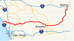
State Route 78 highlighted in red
|
||||
| Route information | ||||
| Defined by | ||||
| Maintained by Caltrans | ||||
| Length: | 215.39 mi (346.64 km) | |||
| Existed: | 1934 – present | |||
| Major junctions | ||||
| West end: |
|
|||
| East end: |
|
|||
| Location | ||||
| Counties: | San Diego, Imperial, Riverside | |||
| Highway system | ||||
|
||||
State Route 78 (SR 78) is a state highway in the U.S. state of California that runs from Oceanside east to Blythe, traversing nearly the entire width of the state. Its western terminus is at Interstate 5 (I-5) in San Diego County and its eastern terminus is at I-10 in Riverside County. The route is a freeway through the heavily populated cities of northern San Diego County and a two-lane highway running through the Cuyamaca Mountains to Julian. In Imperial County, SR 78 travels through the desert near the Salton Sea and passes through the city of Brawley before turning north and passing through an area of sand dunes on the way to its terminus in Blythe.
SR 78 was one of the original state highways designated in 1934, although portions of the route existed as early as 1900. However, it was not designated east of Brawley until 1959. The freeway section in the North County of San Diego that connects Oceanside and Escondido was built in the middle of the twentieth century in several stages, including a transitory stage known as the Vista Way Freeway, and has been improved several times. An expressway bypass of the city of Brawley was completed in 2012. There are many projects slated to improve the freeway due to increasing congestion in the region.
...
Wikipedia

