Calderstones Park
| Calderstones Park | |
|---|---|

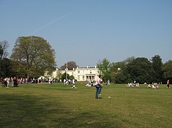
Calderstones Park, showing Calderstones House
|
|
| Type | Public Park |
| Location | Liverpool, England, UK |
| Coordinates | 53°22′54″N 2°53′39″W / 53.38167°N 2.89417°WCoordinates: 53°22′54″N 2°53′39″W / 53.38167°N 2.89417°W |
| Area | 126 acres (0.51 km2) |
| Created | 1905 |
| Operated by | Liverpool City Council |
| Open | All year |
| Status | Open |
| Location | near Allerton |
|---|---|
| Region |
Merseyside, England |
| Coordinates | 53°22′54″N 2°53′39″W / 53.38167°N 2.89417°W |
| Type | Chambered tomb |
| History | |
| Periods | Neolithic |
Calderstones Park is a public park in Liverpool, Merseyside, United Kingdom. The 126 acres (0.51 km2) park is mainly a family park. Within it there are a variety of different attractions including a playground, a botanical garden and places of historical interest. There is a lake in the park with geese and ducks, and the mansion house, which features a café and a children's play area.
The Calderstones are six neolithic sandstone boulders remaining from a dolmen.
Little was known about the Calderstones until the 18th century when they are thought to have been disturbed. In 1825 it was reported that, "in digging about them, urns made of the coarsest clay, containing human dust and bones were found.
During the mid and later 19th century certain academics had declared the Calderstones to have been part of a druidical circle. In the closing years of the century Professor Herdman returned to the earlier evidence and concluded that the stones were once part of a ruined dolmen which had been mistakenly taken for a circle due to the false impression held that all druidical remains should be so arranged.
The six surviving stones are of local sandstone and their sizes range from approximately eight by three feet to three and a half by two and a half feet. The markings which had been studied the previous century by Simpson were again analysed and latex moulds were made of the stones and carvings, which both enabled a precise record to be made and also highlight other worn carvings which were not previously visible. The carvings were placed into six categories; spirals, concentric circles, arcs, cup marks, cup and ring marks and footprints. There is also evidence of post-medieval and modern graffiti. Several of the carvings are similar to examples found in Anglesey and the late-neolithic burial site of Newgrange in the Boyne Valley.
The stones were relocated by Joseph Need Walker during his ownership, becoming a gateway feature to the eponymous estate. The stones are now housed in the Harthill Greenhouses in Calderstones Park having been moved from their previous location in an enclosure just outside the park gates in 1954 to protect them from further weathering.
...
Wikipedia
