Calabanga, Camarines Sur
| Calabanga | |
|---|---|
| Municipality | |

Calabanga Municipal Hall
|
|
| Motto: Saro sa Pagtubod, Saro sa Pag-asenso! | |
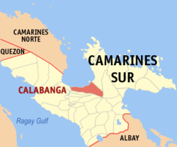
 Map of Camarines Sur showing the location of Calabanga |
|
| Location within the Philippines | |
| Coordinates: 13°43′N 123°14′E / 13.72°N 123.23°ECoordinates: 13°43′N 123°14′E / 13.72°N 123.23°E | |
| Country | Philippines |
| Region | Bicol (Region V) |
| Province | Camarines Sur |
| District | 3rd district |
| Founded | 1578 (Quipayo) 1756 (Calabanga) |
| Barangays | 48 |
| Government | |
| • Mayor | Eduardo E. Severo (Liberal Party) |
| • Vice Mayor | Ramoncito Roco Robles |
| Area | |
| • Total | 163.8 km2 (63.2 sq mi) |
| Population (2015 census) | |
| • Total | 83,033 |
| • Density | 510/km2 (1,300/sq mi) |
| Time zone | PST (UTC+8) |
| ZIP code | 4405 |
| IDD : area code | +63 (0)54 |
| Income class | 1st class; partially urban |
| Website | www |
Calabanga is a first class municipality in the province of Camarines Sur, Philippines. It is composed of 48 barangays, 14 of which are within the urban area and the remaining 34 barangays are within the rural areas. According to the 2015 census, it has a population of 83,033 people, and a land area of 16,380 hectares (40,500 acres), which constitutes 3.1% of the province’s land area.
It is bounded on the west by the Bicol River and beyond the municipality of Cabusao; on the south by the municipality of Bombon and Naga City; on the east by the forest lands of Mount Isarog, the Tigman River and each tributary forming the natural boundary and beyond the municipality of Tinambac; on the north by the fishing grounds of San Miguel Bay, and beyond, the municipalities of Sipocot, Basud and Mercedes.
The topographic landscape of the municipality could be characterized as generally flat with a slope 0-3%, gently sloping (3-8%) towards the direction of the eastern portion and finally rolling up to higher steeps towards the direction of the south-eastern part going to Mt. Isarog. The 0-3% slope is a broad area of flat to nearly level land which extends from Barangay Balongay along the Bicol River to Poblacion area and surrounding areas down to Barangay Manguiring. This is the dominant slope of the municipality.
There are six (6) soil types that could be found in the Municipality. These are the (1) Hydrosol which is dominant along the Bicol River covering parts of Barangays Balongay, San Bernardino and Punta Tarawal; (2) Balong Clay; (3) Pili Clay Loam; (4) Tigaon Clay which covers the poblacion; (5) Annan Clay Loam which could be found toward the direction of Tinambac and (6) Mountain Soil in the Mt. Isarog area.
...
Wikipedia

