Cabanglasan
| Cabanglasan | ||
|---|---|---|
| Municipality | ||

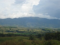
Mountain range in Cabanglasan, Bukidnon
|
||
|
||
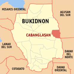
 Map of Philippines with Cabanglasan highlighted |
||
| Location within the Philippines | ||
| Coordinates: 8°04′N 125°19′E / 8.07°N 125.32°ECoordinates: 8°04′N 125°19′E / 8.07°N 125.32°E | ||
| Country | Philippines | |
| Region | Northern Mindanao (Region X) | |
| Province | Bukidnon | |
| District | 2nd district of Bukidnon | |
| Founded | August 13, 1979 | |
| Barangays | 15 | |
| Government | ||
| • Mayor | Renante V. Inocando | |
| Area | ||
| • Total | 243.3 km2 (93.9 sq mi) | |
| Population (2015 census) | ||
| • Total | 33,997 | |
| • Density | 140/km2 (360/sq mi) | |
| Time zone | PST (UTC+8) | |
| ZIP code | 8723 | |
| IDD : area code | +63 (0)88 | |
| Income class | 3rd municipal income class | |
| 101322000 | ||
| Electorate | 18,012 voters as of 2016 | |
| Website | www |
|
Cabanglasan is a third class municipality in the province of Bukidnon, Philippines. According to the 2015 census, it has a population of 33,997 people.
The town was once a Barangay of the capital town, Malaybalay. It was named after a Banglas tree, endemic tree species that inhabit and growing abundantly and distinctively only on this portion of the upper Pulangui. Banglas is hardwood that usually grows in the rocky portion of the Bobunawan riverbanks. Kabanglasan literally means a place that has plenty of Banglas.
Cabanglasan was created as a separate municipality from Malaybalay on August 13, 1979 by virtue of Republic Act 6489.
The movement for the separation of Cabanglasan from his mother municipality (Malaybalay) began in the early 1960s when the people of Pulangi region petitioned for the secession. This prompted the passage of House Bill No. 2789 in Congress by the then Congressman Cesar M. Fortich. The bill was enacted into law without executive approval under Republic Act 6489 but its implementation was delayed due to the declaration of martial law.
Due to the persistence of the residents as spearheaded by Datu Maliwanag(Saturnino P.Linsagan), then President Ferdinand E.Marcos referred the matter to the mother municipality, Malaybalay. A plebiscite was then held wherein the majority voted for the implementation of RA 6489. On August 13, 1979, the first set of municipal officials headed by Mayor Saturnino P. Linsagan aka Datu Maliwanag to his tribesmen, took their oath and held their first session.
Cabanglasan is geographically located between east longitude 125 degrees 27 minutes and north latitude 8 degrees and 3 minutes. It is located at the eastern part of the province of Bukidnon, bounded in the north and west by the City of Malaybalay and the south by the Municipality of San Fernando, and in the east by the province of Agusan del Sur.
It has a total area of 24,330 hectares (60,100 acres), of which 38% is Alienable and Disposable (A&D) land and 62% is timberland. It has 15 barangays, 5 of which are situated within timberland namely; Freedom, Mandahican, Mauswagon, Jasaan, and Cananga-an. Five barangays, namely; Anlugan, Cabanglasan proper, Iba, Mandaing and Dalacutan are located within A&D land while the remaining 5 barangays such as; Cabulohan, Capinonan, Imbatug, Paradise and Mauswagon are located within both timberland and A&D.
It occupies 2.52% of the total provincial area of Bukidnon and 0.74% of the regional area (Northern Mindanao).
The major part of the municipality is classified under slope class 8 to 15 percent. Where such areas are found, it is contiguous to level areas, identified as water retaining areas potentially suited to intensive palay production. Along its North, East and South boundaries is slope class 30% and above, hilly and mountainous are declared as forestal, but not necessarily foliaged. Cabanglasan has an average elevation of 465 meters above sea level.
...
Wikipedia


