C-5 Road
| Circumferential Road 5 | |
|---|---|
| Carlos P. Garcia Avenue | |

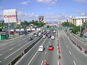
C-5 Road corner Kalayaan Avenue, looking towards Pasig.
|
|
| Route information | |
| Maintained by Department of Public Works and Highways and Metropolitan Manila Development Authority | |
| Length: | 32.5 km (20.2 mi) |
| Component highways: |
|
| Major junctions | |
| Beltway around Metro Manila | |
| North end: | MacArthur Highway (N1) |
| South end: |
|
| Location | |
| Major cities: | Valenzuela, Quezon City, Pasig, Makati, Marikina, Taguig, Parañaque, and Las Piñas |
| Highway system | |
| Highways | Expressways | |
Circumferential Road 5, more commonly known as C-5 Road or C-5, is a network of roads and bridges that altogether forms a major route that transverses in Metro Manila, in the National Capital Region of the Philippines. It is also known officially as Carlos P. Garcia Avenue, and as N11, N128 and N129 in the National Route Numbering System implemented in 2014. Expressway portions, part of the North Luzon Expressway Mindanao Avenue and Karuhatan Link, are numbered E5.
The road serves as a beltway around Metro Manila, spanning some 32.5 kilometres (20.2 mi) as it transverses through the cities of Parañaque, Taguig, Makati, Pasig, Marikina, Quezon City and Valenzuela. It runs parallel to the four other beltways around Metro Manila, and is also known for being the second most important transportation corridor, after Circumferential Road 4, better known as EDSA.
The road is not yet complete to date, because of certain controversies regarding right of way, but portions of the road are already open for public use.
The proposal for the Metro Manila Arterial Road System was done in the late 1960s. The proposal states of building 10 Radial Roads and 6 Circumferential Roads to support the growing vehicular population of the Metropolitan Manila.
...
Wikipedia

