Burgh Heath
| Burgh Heath | |
|---|---|
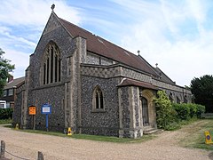
 St Mary's parish church |
|
| Burgh Heath shown within Surrey | |
| Population | 1,884 (2011 Census) |
| OS grid reference | TQ242580 |
| District | |
| Shire county | |
| Region | |
| Country | England |
| Sovereign state | United Kingdom |
| Post town | Tadworth |
| Postcode district | KT20 |
| Dialling code | 01737 |
| Police | Surrey |
| Fire | Surrey |
| Ambulance | South East Coast |
| EU Parliament | South East England |
| UK Parliament | |
Burgh Heath (/ˌbɜːr ˈhiːθ/ or, especially amongst older residents, /ˌbʌrə ˈhiːθ/) is a residential neighbourhood with a remnant part of the Banstead Commons of the same name. Immediately north of Upper Kingswood on the A217 road, it adjoins part of Banstead to the north. The north of the area is more specifically called Great Burgh, but the terms are largely interchangeable.
Burgh or Great Burgh was a very old manor of Banstead with an Old English name which was one of several settlements to have seen very little expansion before the end of the 19th century being on land which was part of the large, and water-scarce Banstead Heath or Common on the North Downs. It developed into a village-like hamlet in the early part of the 20th century.
The Domesday Book records a church at Burgh, connected with its manor held by Odo, Earl of Kent.Rectors were instituted to it in the 14th and 15th centuries, but there is no evidence of its having been a separate parish from Banstead after 1414, in the latter's many governmental and ecclesiastical patent, enquiry and taxation rolls. Bergh or Burgh Church was between Little Burgh House and Church Lane, where the foundations remained supporting a barn until about 1880.
...
Wikipedia

