Buckhorn Wilderness
| Buckhorn Wilderness | |
|---|---|
|
IUCN category Ib (wilderness area)
|
|

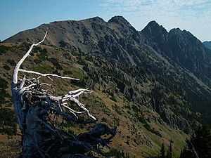
Buckhorn Mountain as seen from the southwest
|
|
| Location | Jefferson / Clallam counties, Washington, USA |
| Nearest city | Quilcene, WA |
| Coordinates | 47°50′N 123°8′W / 47.833°N 123.133°WCoordinates: 47°50′N 123°8′W / 47.833°N 123.133°W |
| Area | 44,319 acres (17,935 ha) |
| Established | 1984 |
| Governing body | U.S. Forest Service |
| Buckhorn Wilderness | |
The Buckhorn Wilderness is a 44,319-acre (17,935 ha) mountainous wilderness area on the northeastern Olympic Peninsula in Washington, USA. Named after Buckhorn Mountain (6,988 ft or 2,130 m), the wilderness abuts the eastern boundary of Olympic National Park which includes nearby Mount Constance (7,756 ft or 2,364 m), Inner Constance (7,667 ft or 2,337 m), Warrior Peak (7,320 ft or 2,230 m), and Mount Deception (7,788 ft or 2,374 m).
In 1984, the U.S. Congress established five wilderness areas within the Olympic National Forest:
Buckhorn Wilderness is the largest of the five, all of which sit on the eastern flank of the Olympic Wilderness within Olympic National Park. Buckhorn Wilderness is administered by the Hood Canal Ranger District of the Olympic National Forest.
The lowest elevations of the Buckhorn Wilderness are found in the lower parts of the three principal drainages: 2,470 feet (750 m) at the Big Quilcene River, 2,700 feet (820 m) at the Dungeness River, and 3,300 feet (1,000 m) at Townsend Creek. The highest point in the wilderness is 7,139 feet (2,176 m) at the summit of Mount Fricaba, which lies on the western boundary of the wilderness area, shared by Olympic National Park. The tallest peak entirely within the wilderness is Buckhorn Mountain at 6,988 feet (2,130 m). A notable historical site in the Buckhorn Wilderness is the Tubal Cain mine.
...
Wikipedia

