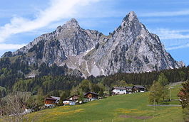
Brunni
| Alpthal | ||
|---|---|---|
 |
||
|
||
| Coordinates: 47°4.2′N 8°42.9′E / 47.0700°N 8.7150°ECoordinates: 47°4.2′N 8°42.9′E / 47.0700°N 8.7150°E | ||
| Country | Switzerland | |
| Canton | Schwyz | |
| District | Schwyz | |
| Area | ||
| • Total | 22.88 km2 (8.83 sq mi) | |
| Elevation (Kirche Alpthal) | 996 m (3,268 ft) | |
| Population (Dec 2016) | ||
| • Total | 612 | |
| • Density | 27/km2 (69/sq mi) | |
| Postal code | 8849 | |
| SFOS number | 1361 | |
| Localities | Eigen, Alpthal, Brunni, Holzegg | |
| Surrounded by | Einsiedeln, Oberiberg, Rothenthurm, Schwyz | |
| Website |
www SFSO statistics |
|
Alpthal is a village and municipality in Schwyz District in the canton of Schwyz in Switzerland. Besides the village of Alpthal, the municipality includes the ski resort of Brunni, and settlement of Eigen.
Alpthal is first mentioned in 1018 as Albetal. A branch of the Camino de Santiago pilgrimage route connected Einsiedeln with Schwyz via Alpthal and the Haggenegg.
Winter tourism first came to Alpthal in 1950, with the opening of the cable car from Brunni to the Holzegg. Brunni acquired its first ski lift in 1964, and the Brunni-Haggenegg ski area was commissioned in 1974.
The village of Alpthal is located in the upper reaches of the Alptal, the valley of the river Alp upstream from Einsiedeln. Also within the municipality of Alpthal are the popular ski resort of Brunni, 3.3 km (2.1 mi) higher up the valley, and the settlement of Eigen, 2.1 km (1.3 mi) down the valley. To the north and beyond Eigen, the Alp flows through the village Trachslau and further through the town of Einsiedeln some 7 km (4.3 mi) beyond. To the west, south and east the municipality is surrounded by the peaks of the Nüsellstock, Näbikenfirst, Grossbrechenstock, Kleiner Mythen, Grosser Mythen, Rotenfluh, and Gschwändstock. The Haggenegg, between the Kleiner Mythen and the Grossbrechenstock, and the Holzegg, between the Grosser Mythen and Rotenfluh, both cross towards Schwyz. Both Mythen and Hagenegg belong however to the municipality of Schwyz.
The municipality has an area, as of 2006[update], of 22.9 km2 (8.8 sq mi). Of this area, 32.4% is used for agricultural purposes, while 62.8% is forested. Of the rest of the land, 1.6% is settled (buildings or roads) and the remainder (3.2%) is non-productive (rivers, glaciers or mountains).
...
Wikipedia


