Brooksville, Mississippi
| Brooksville, Mississippi | |
|---|---|
| Town | |
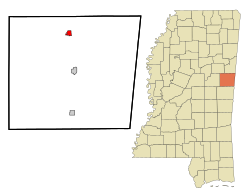
 Location of Brooksville, Mississippi |
|
| Location in the United States | |
| Coordinates: 33°13′58″N 88°34′54″W / 33.23278°N 88.58167°WCoordinates: 33°13′58″N 88°34′54″W / 33.23278°N 88.58167°W | |
| Country | United States |
| State | Mississippi |
| County | Noxubee |
| Area | |
| • Total | 1.0 sq mi (2.6 km2) |
| • Land | 1.0 sq mi (2.6 km2) |
| • Water | 0.0 sq mi (0.0 km2) |
| Elevation | 279 ft (85 m) |
| Population (2000) | |
| • Total | 1,182 |
| • Density | 1,189.1/sq mi (459.1/km2) |
| Time zone | Central (CST) (UTC-6) |
| • Summer (DST) | CDT (UTC-5) |
| ZIP code | 39739 |
| Area code(s) | 662 |
| FIPS code | 28-08980 |
| GNIS feature ID | 0667603 |
Brooksville is a town in Noxubee County, Mississippi. The population was 1,182 at the 2000 census.
The Sam D. Hamilton Noxubee National Wildlife Refuge is located west of the town, and the Black Prairie Wildlife Management Area is located to the north.
The town's name comes from the several brooks which flow nearby.
A post office was established in 1846, and the town was incorporated in 1860.
Brooksville was a stop on the Mobile and Ohio Railroad, built in the 1850s.
Brooksville has a large Mennonite community.
Brooksville is located at 33°13′58″N 88°34′54″W / 33.23278°N 88.58167°W (33.232853, -88.581600).
According to the United States Census Bureau, the town has a total area of 1.0 square mile (2.6 km2), all land.
At the census of 2000, there were 1,182 people, 439 households, and 305 families residing in the town. The population density was 1,189.1 people per square mile (461.0/km²). There were 480 housing units at an average density of 482.9 per square mile (187.2/km²). The racial makeup of the town was 19.12% White, 79.61% African American, 0.17% Asian, and 1.10% from two or more races. Hispanic or Latino of any race were 1.10% of the population.
...
Wikipedia

