Brookhaven, Georgia
| Brookhaven, Georgia | ||
|---|---|---|
| City | ||
| City of Brookhaven | ||

Brookhaven Village, located on Dresden Drive east of Peachtree Road
|
||
|
||
| Nickname(s): Brookhaven, North Atlanta | ||
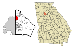
| Location of Brookhaven in Metro Atlanta | ||
| Coordinates: 33°51′33″N 84°20′20″W / 33.85917°N 84.33889°WCoordinates: 33°51′33″N 84°20′20″W / 33.85917°N 84.33889°W | ||
| Country | United States | |
| State | Georgia | |
| County | DeKalb | |
| Government | ||
| • Mayor | John Ernst | |
| • City Manager | Christian Sigman | |
| Population (2014) | ||
| • Total | 51,029 (est.) | |
| Time zone | Eastern (EST) (UTC-5) | |
| • Summer (DST) | EDT (UTC-4) | |
| ZIP codes | 30319, 30341 | |
| Area code(s) | 404/678/770 | |
| FIPS code | 13-10944 | |
| GNIS feature ID | 331243 | |
| Website | http://brookhavenga.gov | |
| North Atlanta, Georgia | |
|---|---|
| Former CDP | |
 Location in DeKalb County and the state of Georgia |
|
| Country | United States |
| State | Georgia |
| County | DeKalb |
| Area | |
| • Total | 7.8 sq mi (19.9 km2) |
| • Land | 7.7 sq mi (19.8 km2) |
| • Water | 0.1 sq mi (0.1 km2) |
| Elevation | 1,004 ft (306 m) |
| Population (2010) | |
| • Total | 40,456 |
| • Density | 5,187/sq mi (2,033/km2) |
| Time zone | Eastern (EST) (UTC-5) |
| • Summer (DST) | EDT (UTC-4) |
| ZIP code | 30319 |
| Area code(s) | 404 |
| FIPS code | 13-56000 |
| GNIS feature ID | 0332512 |
Brookhaven is a city in the northeastern suburbs of Atlanta. Home to about 51,029, it is located in western DeKalb County, Georgia, United States, directly northeast of Atlanta. On July 31, 2012, Brookhaven was approved in a referendum to become DeKalb County's 11th city. Incorporation officially took place on December 17, 2012, on which date municipal operations commenced. With a population of around 49,000, it is the largest city in DeKalb County. The new city stretches over 12 square miles.
Brookhaven's first permanent European settler was John Evins, who started a plantation around 1810. Harris and Solomon Goodwin, who moved to Georgia from South Carolina, became owners of the land in the 1830s. The Goodwin home and the family graveyard have been preserved at the 3900 block of Peachtree Road, near Dresden Drive. A train station known as Goodwin's was constructed along the Atlanta and Richmond (later Atlanta and Charlotte) railway in 1873.
The settlement of Cross Keys, with a population of 250 in 1876, was located one mile (2 km) north along the rail line from Goodwin's. In 1879 Cross Keys was described:
Nancy's Creek furnished power for operating a mill. The place has two churches—Methodist and Baptist—one common school, and steam cotton gins. Cotton and wood form the chief exports. About 140 bales of cotton shipped per annum, most of which is carried to Atlanta by wagon. Population within a radius of 2 miles [3 km], near 400. Mail daily… Depot and station [is] one and one-quarter miles [2.0 km] distant [from] this place.
Atlanta residents began constructing summer cottages in the community around 1900. In 1910, 150 acres (61 ha) on the north side of Peachtree Road were purchased for development as a planned community surrounding a golf course. The nine-hole golf course, designed by Herbert Barker, a golf pro from Garden City, Long Island, opened in 1912. Residences developed in three phases, with Brookhaven Estates designed in 1910, followed by Country Club Estates in 1929 and the Carleton Operating Company in 1936. Independently, Edwin P. Ansley sold lots in the area, calling it Oglethorpe Park. Construction of the historic neighborhood was largely complete by the end of World War II. The country club became part of the downtown Capital City Club in 1911, and its name was changed to the Capital City Country Club. The golf course was expanded from nine to eighteen holes in 1915. The clubhouse, designed by Preston Stevens in the French Provencial style, was completed in 1928.
...
Wikipedia


