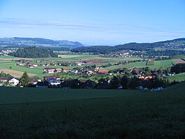
Brenzikofen
| Brenzikofen | |
|---|---|
 |
|
| Coordinates: 46°49′N 7°37′E / 46.817°N 7.617°ECoordinates: 46°49′N 7°37′E / 46.817°N 7.617°E | |
| Country | Switzerland |
| Canton | Bern |
| District | Bern-Mittelland |
| Area | |
| • Total | 2.2 km2 (0.8 sq mi) |
| Elevation | 583 m (1,913 ft) |
| Population (Dec 2015) | |
| • Total | 519 |
| • Density | 240/km2 (610/sq mi) |
| Postal code | 3671 |
| SFOS number | 0606 |
| Surrounded by | Bleiken bei Oberdiessbach, Fahrni, Heimberg, Herbligen, Oberdiessbach, Oppligen |
| Website |
http://www.brenzikofen.ch SFSO statistics |
Brenzikofen is a municipality in the Bern-Mittelland administrative district in the canton of Bern in Switzerland.
Brenzikofen is first mentioned in 1236 as Brenzichovin.
During the Late Middle Ages Interlaken Abbey owned much of the land in the village. The remainder of the land was owned by wealthy citizens of the towns of Bern and Thun. During the Middle Ages, Diessenberg Castle was built on Bürglen hill above the village. Little is known about the castle and today only portions of the wall and ditch are still visible. Bern gradually acquired more rights in the village over the following centuries. In 1528, Bern adopted the Protestant Reformation and secularized Interlaken Abbey and all of its land holdings, including Brenzikofen. Beginning in 1652, it was part of the district of Thun. Following the 1798 French invasion, under the Helvetic Republic it became part of the district of Konolfingen. It has always remained part of the parish of Oberdiessbach.
The village was part of a school district with Herbligen until 1834. The district was reestablished in 1973, when a new school house was built. In 1898, the Burgdorf-Thun railroad built a station in Brenzikofen. In 1983, the central Army Catering Headquarters was established and became the major employer in the village.
Brenzikofen has an area of 2.2 km2 (0.85 sq mi). Of this area, 1.19 km2 (0.46 sq mi) or 54.1% is used for agricultural purposes, while 0.82 km2 (0.32 sq mi) or 37.3% is forested. Of the rest of the land, 0.19 km2 (0.073 sq mi) or 8.6% is settled (buildings or roads), 0.01 km2 (2.5 acres) or 0.5% is either rivers or lakes.
...
Wikipedia


