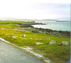
Brenish
Brenish
|
|
|---|---|
 Brenish coastline |
|
| Brenish shown within the Outer Hebrides | |
| Population | 25 |
| Language |
Scottish Gaelic English |
| OS grid reference | NA991261 |
| Civil parish | |
| Council area | |
| Lieutenancy area | |
| Country | Scotland |
| Sovereign state | United Kingdom |
| Post town | ISLE OF LEWIS |
| Postcode district | HS2 |
| Dialling code | 01851 |
| Police | Scottish |
| Fire | Scottish |
| Ambulance | Scottish |
| EU Parliament | Scotland |
| UK Parliament | |
| Scottish Parliament | |
Brenish (Scottish Gaelic: Brèinis) is a small village situated on the west coast of the Isle of Lewis, which is part of the Outer Hebrides of Scotland. Brenish is within the parish of Uig. The name of the village is sometimes spelt Breanish (which is generally the spelling used locally), however maps normally refer to Brenish.
Brenish is commonly regarded as one of the more scenic areas on the island, although its remote location at the end of the winding and decaying C39 makes it one of the less visited. The village itself runs parallel to the Atlantic coastline and is overlooked by Mealisval, the tallest mountain on the island. It is located next to the village of Mealista which is an uninhabited village known best for its selection of virginal sandy beaches. Mealista is where the road ends, making Brenish the last populated village on the C39.
Brenish can be reached by taking the A859 from Stornoway or Tarbert, Harris, then turning on to the A858 towards Garynahine. This route then travels along the B8011, which then becomes the C39 at Timsgarry. The journey takes between 60 and 90 minutes from Stornoway and 90 to 120 minutes from Tarbert (depending on driving experience on the Lewis roads).
One of the more interesting features of Brenish is the Blowhole. This is a deep hole in the ground which is roughly 20 metres inland. It has a sea cave which funnels sea water into the hole, sometimes with such ferocity that the sea water blows out the top of the hole. The hole is situated to the north of the village and although it is large it can easily be missed because it is situated in a dip in the ground. There is no fencing around the hole making it a hazard to the unsuspecting walker.
...
Wikipedia

